Michigan Water Science Center
|
ABOUT THE Michigan
|
About the Michigan Water Science CenterThe Michigan Water Science Center (WSC) is one of 48 Water Science Centers in the Water Resources Discipline of the U.S. Geological Survey (USGS). The Water Science Center's mission is to collect, analyze and disseminate the impartial hydrologic data and information needed to wisely manage water resources for the people of the United States and the State of Michigan. Contact information for the main Michigan WSC office: Michigan Water Science Center Office InformationWhat We Do
To assure that our work is relevant and useful, we form partnerships with Federal, State, and local agencies, and other public organizations. Funding for the Michigan Water Science Center comes from a variety of sources, including direct Federal appropriations, other Federal agencies, and a cooperative program that allows the Michigan Water Science Center to partially match funding with state and local agencies. Information concerning USGS products and services can be obtained from: The Michigan WSC home page provides direct access to current and historical USGS streamflow data, a bibliography of Michigan Water Science Center reports, and much more about USGS operations in the state of Michigan. Data Collection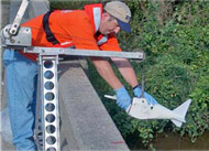
Basic hydrologic data collection, processing, analysis, dissemination, and archiving are major parts of the Michigan Water Science Center program. Streamflow data, for example, are used for flood and water-supply forecasts, planning and design, river regulation, streamflow statistics, and research investigations. Much of the data are available on a near-real-time basis by satellite telemetry. Types of data currently collected include:
Database Capabilities
USGS data are stored and maintained in long-term, quality-assured data bases. The data bases contain data for Michigan and the rest of the nation and are accessible to the public. The data include:
ProjectsThe chief purpose of hydrologic projects is to help cooperating agencies solve water problems. For example, investigative results have been used to manage storm-water runoff, to develop ground-water management plans, and to identify areas of water-quality degradation. These investigations address many water issues:
Analytical Techniques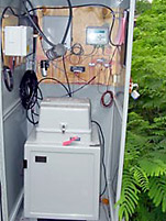
The Michigan Water Science Center uses state-of-the-art as well as traditional methods that include quality assurance and quality control:
Water-quality samples are collected and analyzed for a wide range of constituents, including major inorganics, nutrients, trace elements, dissolved gases, pesticides, isotopes, organic solvents, petrochemicals, and biological indicators. |
![]() U.S. Department of the Interior |
U.S. Geological Survey
U.S. Department of the Interior |
U.S. Geological Survey
URL: http://mi.water.usgs.gov/about/index.html
Page Contact Information: gs-w-milns_webmaster@usgs.gov
Page Last Modified: Tuesday, 03-Jan-2017 11:07:34 EST

![[Map: There is a USGS Water Science Center office in each State.]](/_images/imagemaps/usmapsmall.gif)