Glacial Aquifer System Groundwater Availability Study
ContactHoward W. Reeves
USGS IN YOUR STATEUSGS Water Science Centers are located in each state. 
|
Preliminary work for the study began in the summer of 2011. The project is planned for 2012-16, and the study will be conducted by a team of researchers from several USGS Science Centers across the study area. The tasks planned for the study include: Click on a topic below or --> [ Open All | Close All ] Hydrologic framework and conceptual flow models:
This project focuses on the hydrogeologic and climatic controls on groundwater availability in the glacial aquifer system. We are synthesizing past studies to develop the framework and identify the most important features of the system across the study area. The framework and conceptual flow models are necessary to communicate aspects of regional groundwater availability and for future detailed analysis. (contact: Howard Reeves, Michigan Water Science Center)
Standardized water-well record database:
Over the past decade or so, many states have developed electronic databases to store water-well record information and many have put older records into these databases. Information on water-well records includes descriptions of the material encountered when drilling the well, location of well screen, depth to water at the time of drilling, and location. Although some individual records are not as detailed as others, when taken as a whole, these millions of records provide insight to the three-dimensional distribution of glacial material across much of the study area. The state records available to the study are being combined with USGS electronic records to create a standardized water-well record database for the glacial aquifer system. The reported material descriptions are being converted to a standard set of codes and a maps showing an index of material from fine to coarse are being developed (as an example of an application in the Lake Michigan Basin, see Arihood, 2009. This information will be used in development of the hydrogeologic framework and in other parts of the groundwater availability study. (contact: Randy Bayless, Indiana Water Science Center)
Bedrock topography map of glaciated United States east of the Rocky Mountains:
A raster-based map and GIS database for bedrock topography, which may be used to estimate the thickness of glacial deposits, is being generated. This map and dataset provides estimates between the contour levels of a vector-based map to provide a continuous surface that has been requested by many users. (contact: Dave Soller, Eastern Geology and Paleoclimate Science Center)
Regional-scale groundwater budget:
Understanding the groundwater budget for a region is an important first step in development of groundwater-flow models and in the design of field experiments to study how the groundwater system responds to changes in pumping or climate. The response of the system ultimately determines groundwater availability. We are gathering information and analyzing the major components of the regional groundwater budget for the glacial aquifer system.
Recharge:
A soil-water balance approach using daily climate data is being used to estimate the pattern and dynamics for recharge to the shallow glacial aquifer system. (contacts: Steve Westenbroek, Wisconsin Water Science Center; Tim Cowdery, Minnesota Water Science Center)
Discharge:
Natural discharge from the glacial aquifer system includes baseflow to streams in the study area. Previous work quantifying baseflow at USGS streamgages will be used to estimate natural discharge of the system. (contact: Howard Reeves, Michigan Water Science Center)
Water withdrawals:
In addition to quantifying the natural discharge from the system, current and historical water withdrawals from glacial aquifers are needed to develop an understanding of the response of the system to withdrawals. Data from the USGS Water Use Program will be used to quantify water withdrawals for the study area. (contacts: Kyle Davis, South Dakota Water Science Center; Kathleen Rowland, North Dakota Water Science Center)
Storage:
Although estimates of groundwater in storage should not be used to imply groundwater availability, estimates of groundwater in storage and the distribution of this water is useful in developing an understanding of the groundwater system. This task will synthesize previous studies and information from water-well records to estimate bounds for the amount of groundwater in storage in the glacial aquifer system in the conterminous United States. (contact: Chris Hoard, Michigan Water Science Center)
Trend and correlation analysis:
One challenge to understanding groundwater availability in the glacial aquifer system is to document how different parts of the system have changed over time in response to development and climate variations. In parts of the system, only limited direct observations of groundwater levels are available and correlation of groundwater conditions to other measured conditions are needed. Current work includes assembling data sets needed to analyze trends in time and correlations for groundwater conditions using groundwater-level data and related data such as snowpack data. These data will be examined to identify groundwater data that is impacted by human influences such as urbanization and pumping. (contacts: Glenn Hodgkins and Robert Dudley, Maine Water Science Center)
Numerical modeling for groundwater availability assessment:
Numerical models that quantify the response of the groundwater system to development or changes in climate are typically used to assess groundwater availability. The glacial aquifer system is so large that a single groundwater-flow model is neither practical nor reasonable. Rather than attempting a single model in this project, we are focusing on 3 goals: (1) use of smaller regional groundwater-flow models in different parts of the study area to illustrate and quantify important differences, (2) development and application of numerical methods capable of better quantifying local groundwater/surface-water interaction within regional models, and (3) development and application of statistical methods capable of extending detailed groundwater-flow models to un-modeled areas to provide insight and analysis before detailed modeling is completed. (contact: Daniel Feinstein, Wisconsin Water Science Center)
|
![]() U.S. Department of the Interior |
U.S. Geological Survey
U.S. Department of the Interior |
U.S. Geological Survey
URL: http://mi.water.usgs.gov/projects/WaterSmart/approach.html
Page Contact Information: gs-w-milns_webmaster@usgs.gov
Page Last Modified: Wednesday, 26-Dec-2012 17:58:46 EST

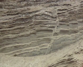 Glacial outwash near Ely, Minnesota, Photo by Chris Hoard, USGS