- Identify the areas that supply public drinking water.
- Inventory contaminants and assess water susceptibility to contamination.
- Inform the public of the results.
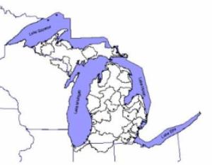
Water for more than 80 percent of the population in Michigan comes from surface-water sources that include the Great Lakes, the Upper Great Lakes Connecting Channels, and inland lakes and rivers. This study developed assessment methodologies to determine the risk for contamination of each of these sources at locations where water is withdrawn from them for municipal use. The assessment process was being developed by USGS in partnership with MDEQ and the approximately 70 water supplies that use surface-water sources. Completed assessments provide each water supply with a map of their source water area, a comprehensive inventory of potential contaminant sources within the source water area, and a determination of the relative sensitivity and susceptibility of the intake(s).
USGS helped MDEQ define protocols to implement this EPA-mandated program throughout Michigan. Methods were developed to delineate areas contributing water to drinking water supplies statewide, including Great Lakes intakes, inland rivers, and karst areas.
Links to Other Resources:
Microsoft® PowerPoint® Presentation:
If you do not have Microsoft® PowerPoint®, you can download a viewer for free at:
Microsoft®
PowerPoint® Viewers
Use of this software product does not imply endorsement by U.S. Government.
Cooperator:
Department of Environmental Quality - Source Water Assessment Program
References:


