 |
|
|
||||
| Michigan Water Science Center |
|
Project Chief Mike Sweat Statewide Water Resources Monitoring Protection of Drinking Water Sources Effects of Land Use on Water Quality
Restoring Natural Flow Regimes Research and Technical Assistance at Contaminated Sites Table of Contents |
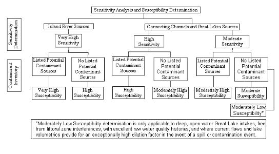
Only 7 supplies in Michigan get their source water from inland rivers. These supplies are located on the River Raisin (3 supplies), the Pine River, the Flint River, the Indian River, and the Huron River. Some of these supplies have intakes located behind impoundments in the rivers, others from pipes in the shore or bottom of the river. Inland river supplies intakes and their source water areas are very highly sensitive to their natural setting. The susceptibility, or risk of contamination, from human activities ranges from high to very high. Sensitivity Analysis and Susceptibility Determination flowchart Click on image to go to larger version (36 KB).
Links to Other Resources: Cooperator: |

![]() U.S. Department of the Interior |
U.S. Geological Survey
U.S. Department of the Interior |
U.S. Geological Survey
URL:
Page Contact Information: Webmaster(gs-w-milns_webmaster@usgs.gov)
Page Last Modified: Last modified: June 23 2006 11:00:47.