
Estimated rates of direct ground-water discharge to Lake Michigan range from 800 to 6,700 cubic feet per second. Highest rates are calculated for the northeastern shore of the Lake. Using generalized values, total direct ground-water discharge to Lake Michigan was estimated to be about 2,700 cubic feet per second. Insufficient data are available to make similar estimates for the remaining Great Lakes (Huron, Superior, Erie, and Ontario), but estimated rates from six studies are much smaller than those from studies for Lake Michigan.
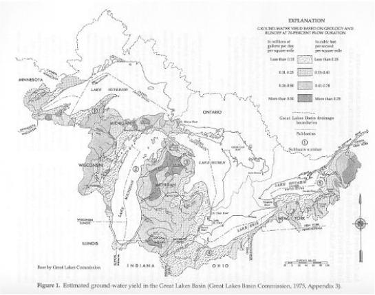
The amount of direct ground-water discharge to the Great Lakes (fig. 1) has been difficult to estimate since the first detailed water-budget analyses for the Lakes were prepared. Contributions from ground water have been largely ignored or considered insignificant in many of these budget analyses. Current (1998) forecasting models account for ground-water discharge to the lakes by adjusting rates of lake evaporation. Estimates of direct ground-water discharge to portions of the Great Lakes have been made and described in a few studies. Most of this work was done to help understand transport of solutes to the lakes from near-shore aquifers, a problem that also remains largely unsolved.
This report constitutes a compilation of publications on ground water and the Great Lakes to present estimates or evidence of direct ground-water discharge to the Great Lakes. The compilation is intended to help determine if direct ground-water discharge to the Lakes is large enough to be incorporated in water-budget calculations. Twenty seven references are annotated in this report containing information for estimating direct ground-water discharge to the lakes.
Because the Great Lakes occupy low-lying parts of the landscape, ground-water flow is from uplands toward the Lakes under natural conditions. Ground-water discharge to the Lakes is derived from two principal sources. The largest source is the near-shore environment where water that infiltrates onshore discharges near the shoreline. This also is the simplest component of flow to evaluate. Another source is water that enters the ground-water system more distant from the shore and flows in a regional flow system to the Lakes. A factor that complicates direct discharge estimates is associated with bays and river mouths that focus ground-water discharge into the bay or inlet. Ground-water withdrawals near major metropolitan areas also complicate estimates of direct ground-water discharge because they may cause the direction of flow to reverse.
Discharge from Near-Shore Sources
Most studies reviewed for this report evaluate hydraulic properties of near-shore rocks or unconsolidated materials and hydraulic properties of lake-bottom materials. These properties were used to calculate the amount of direct ground-water discharge using approximated or measured hydraulic gradients near shore. These studies generally indicate that ground-water flow into the lakes is not an important factor in areas with clay and silty clay bottom materials. However, in areas of the lakes with sandy or silty sand bottom materials, ground-water inflow may be an appreciable part of the water budget. Other factors, such as heterogeneities within the lake bed, shoreline configuration, onshore heads and topography, lake bathymetry, and the hydraulic properties of geologic materials beneath the lake also may be critical for accurately estimating direct ground-water discharge.
One of the earliest estimates of ground-water discharge to Lake Michigan (800 ft3/s) was by Bergstrom and Hansen (1962). Several other estimates of ground-water discharge to parts of Lake Michigan and Green Bay, based on geophysical and seepage-meter measurements, have been made by hydrologists in Wisconsin (Bradbury, 1982; Cherkauer and Hensel, 1986; Cherkauer and cKereghan, 1991). Some of these estimates were based on ground-water-flow models that include the Wisconsin shoreline. These estimates are not intended to represent the Lake as a whole and are stated in discharge rate per unit length of shoreline.
For the eastern shore of Lake Michigan, calculations based on ground-water-flow models have been made by the U.S. Geological Survey (USGS) (Hoaglund and others, 1995) and by the Great Lakes Environmental Research Laboratory (Sellinger, 1995). The Canadian Department of the Environment calculated ground-water inflow to Lake Ontario from the Canadian side (Haefeli, 1972). The USGS (Gillespie and Doumouchelle, 1989) U.S. Environmental Protection Agency (Taylor and Cherkauer, 1987), and Environment Canada (Sklash and others, 1986) made estimates of direct ground-water discharge to parts of the upper Great Lakes connecting channels. Few other large-scale estimates of discharge from near-shore sources were found in the literature search as part of this study.
Little information has been found for the northern shore of Lake Michigan and eastern shore of Lake Huron, representing a large portion of the lake system for which no estimates have been made. For the remainder of the lakes, discharge estimates were made for a few studies of aquifer systems near the lake shore. This is the case for the Lake Superior shore where few studies have been done except in and near the metropolitan areas.
Cartwright, Keros, Hunt, C.S., Hughes, G.M., and Brower, R.D., 1979, Hydraulic potential in Lake Michigan bottom sediments: Journal of Hydrology, vol. 43, p. 67-78.
Part of "Conclusions"
"From such a limited data base, it is hazardous to estimate the groundwater contribution to Lake Michigan. However, some observations seem necessary and appropriate at this time. In the past, the groundwater contribution has generally been neglected as insignificant, or has been assumed not to exist at all.
Using a water budget, Bergstrom and Hansen (1962) estimated the total ground-water contribution or 'shore discharge' to Lake Michigan to be 7.2 * 108 m3/yr (800 ft3/s); assuming a 58,000 km2 (22,400 mi2) lake area (Hough, 1958), this equals 1.2 * 104 m3/yr/km2 (0.03 ft3/s/mi2). Based on the groundwater flux determined in this study, discharges of 1.9 * 107 m3/yr/km2 (55 ft3/s/mi2) from sandy bottom areas and 5.0 * 103 m3/yr/km2 (0.02 ft3/s/mi2) from fine-grained areas are calculated. In a 58,000 km2 (22,400 mi2) lake, discharge through the fine-grained lake sediments amounts to about 2.9 * 108 m3/yr (325 ft3/s), similar to that calculated by Bergstrom and Hansen without considering areas of sand with a flux similar to that calculated for this one sand body. Our best estimate of total near-shore sand area is 800 km2 (309 mi2) based on unpublished maps of Lake Michigan (D.L. Gross, pers. commun., 1976); this calculates to be a discharge of 5.7 * 109 m3/yr (6,380 ft3/s). Combining the discharges from the near-shore sands and the fine grained lake sediments, we calculate the total groundwater discharge to the lake to be 6.0* 109 m3/yr. (6,700 ft3/s) or 1.0* 105 m3/yr/km2 (0.29 ft3/s/mi2). This suggests that the total discharge to the lake is directly related to the area underlain by the near-shore sand bodies and may be much greater than that previously calculated." (p. 76)
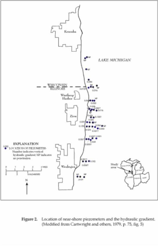
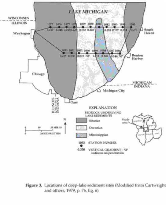
Cartwright and others (1979) installed piezometers to measure hydraulic gradient in near-shore sediments (fig. 2). They also measured hydraulic gradients in deep-lake sediments by measuring pore pressure. Two transects from Wisconsin to Michigan were completed as part of their study (fig. 3). (Reprinted from Jounral of Hydrology, vol. 43, p. 67-78, copyright 1979, with permission from Elsevier Science.)
Cherkauer, D.S., and Zvibleman, B., 1981, Hydraulic connection between Lake Michigan and a shallow ground-water aquifer: Ground Water, vol. 19, no. 4, p. 376-381.
"Abstract"
"Pumping from a dolomite aquifer adjacent to Lake Michigan has reversed the natural hydraulic gradient so that lake water has been induced to flow into the aquifer. Because lake water is much lower in dissolved solids than the ambient ground water, the induced recharge is traceable as a dis- tinct plume of high-quality water over a mile long. The configuration of the plume allows interpretation of the hydraulic connection between the lake and the aquifer. Most of the induced recharge enters the aquifer through the lake bed at locations where the most permeable parts of the aquifer are overlain by relatively thin lake-bed sediments which, in turn, are at least partly sand and gravel. It continues inland along zones of high hydraulic conductivity." (p. 376)
No estimates of the rate at which water is induced from the lake to the aquifer is made in this article but it does provide insight into the factors that are important for evaluating direct ground-water discharge to the Lakes. (Reprinted with the permission of Ground-Water Publishing Company, Copyright, 1998.)
Bradbury, K.R., and Taylor, R.W., 1985, Determination of the hydrogeologic properties of lakebeds using offshore geophysical surveys: Ground Water, vol. 22, no. 6, p. 690-695.
"Abstract"
"Studies of the relationships between ground-water systems and surface-water systems (lakes) generally require knowledge of the hydrogeologic properties of lakebed materials. Direct measurement of these properties may be prohibitively expensive or difficult in an offshore environment. A correlation between longitudinal conductance, a geoelectric parameter, and lakebed leakance (vertical hydraulic conductivity divided by thickness) may provide a rapid and inexpensive method for estimating lakebed hydrogeological properties using data collected by offshore seismic and electrical surveys. A test of the method at three study sites in Lake Michigan shows a positive linear relationship between the logarithm of longitudinal conductance and the logarithm of lakebed leakance at the three sites." (Reprinted with the permission of Ground-Water Publishing Company, Copyright, 1998.)
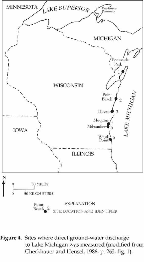
Cherkauer, D.S. and Hensel, B.R., 1986, Groundwater flow into Lake Michigan from Wisconsin: Journal of Hydrology, vol. 84(3/4), p. 261-271.
"Abstract"
"Detailed hydrogeological study has been done at six sites along the Lake Michigan shoreline in Wisconsin. At each site a flux of groundwater to the lake has been calculated for both natural conditions and the existing conditions created by pumping. The values from each site have then been extrapolated to the entire portion of the total shoreline having similar hydrogeology in order to calculate a total flow of groundwater to the lake. Sensitivity analysis with a digital model was used to define limits on the similarity of hydrogeologic conditions.
The net flow calculated is 580-880 m3/day/km (0.38-0.58 ft3/s/mi) of shoreline, which falls within the previously published range of 110-8200 m3 /day/km (0.07-5.39 ft3/s/mi). Human activity may have reduced the natural flow as much as 15 percent. The estimated natural flow is between 7 and 11 percent of the surface water contribution to the lake from the study area."
Flow values used to estimate ground-water discharge to Lake Michigan from Wisconsin are listed for each site. The total rate for observed conditions ranges from 228,000 to 377,000 m3/day (93 to 154 ft3/ s); under simulated natural conditions the total rate ranges from 272,000 to 414,000 m3/s (111 to 169 ft3/s).
Cherkauer and Hensel comment below about the difference between their estimates and those of Cartwright and others (1979).
"The flow calculated by Cartwright et al. (1979) is an order of magnitude higher than the new values. It is important to note that 95% of Cartwright et al's calculated flow came from nearshore sand bodies similar to those at Point Beach. In this study, 60-70% of the discharge to the lake at Point Beach was found to come from the sand unit. However, throughout the study area, Point Beach type sands probably produce no more than 5% of the total groundwater influx to the lake. We believe the difference in these estimates lies with Cartwright et al's use of the grain size of the sand to approximate its hydraulic conductivity. At Point Beach, that same method tended to overestimate conductivity by as much as an order of magnitude. If the sand conductivity used by Cartwright et al. were reduced one order of magnitude, their estimated discharge would be about 1200 m3/day/km, a value much closer to the range established in this paper." (p. 269 and fig. 4 of this report). (Reprinted from Jounral of Hydrology, vol. 84, (3/4), pp. 261-271, copyright 1979, with permission from Elsevier Science.) Cherkauer, D.S., and Nader, D.C., 1989, Distribution of groundwater seepage to large surface-water bodies: the effect of hydraulic heterogeneities: Journal of Hydrology, vol. 109(1/2), p. 151-165.
"Abstract"
"At 26 sites on the upper Great Lakes and their connecting channels where groundwater seepage measurements have been made, seepages decrease continually offshore at only seven (26%). Instead, 17 (62%) of the sites have offshore seepages which substantially exceed those at some locations closer to shore. The distributions fall into two consistent patterns, one where a nearshore decrease in seepage with increasing distance is succeeded offshore by an increase and a second where nearshore seepages are relatively constant and then increase farther offshore. The patterns have been observed in two independent studies using two totally different seepage meter designs and emplacement methods and are attributed to hydrogeologic heterogeneities beneath the surface-water body.
Detailed marine geophysical measurements at seven sites on Green Bay show that the anomalously high offshore seepages there are associated with local thinning of the relatively low hydraulic conductivity glacial sediments separating the Bay from the underlying aquifer, a fractured dolomite. At these locations, heterogeneity in sediment thickness is a stronger factor in causing seepage anomalies than is heterogeneity of either sediment or bedrock hydraulic conductivity. Insufficient information exists to confirm a parallel cause effect relation at the other sites, but evidence points in that direction.
Similar seepage anomalies have been observed at other, smaller lakes by other researchers, but never with this frequency. It is argued that the cause of the difference is the size of the Great Lakes. Seepage occurs and measurements have been made over much greater offshore distances than in smaller lakes, and the likelihood that heterogeneities can occur within the zone of measurement is thus also much greater." (p.151).
(Reprinted from Jounral of Hydrology, vol. 109, p. 151-165, copyright 1989, with permission from Elsevier Science.)
Cherkauer, D.S., McKereghan, and Schalch, L.H., 1992, Delivery of chloride and nitrate by ground water to the Great Lakes: Case study for the Door Peninsula, Wisconsin: Ground Water, vol. 30(6), p. 885-894.
The authors used a finite-element-transport model that "drew heavily upon an earlier simulation by Nauta (1987)." Although the mass of chloride and nitrate delivered to Green Bay and Lake Michigan was the emphasis of this study, ground- water discharge to the Lake was calculated as part of the model simulation. This discharge rate is about the same as simulated by Nauta (8.4 ft3/s to Lake Michigan and 6.4 ft3/s to Green Bay). (Reprinted with the permission of Ground Water Publishing Company. Copyright 1998.)
Visocky, A.P., 1977, Hydrologic study of Illinois Beach State Park: Illinois State Water Survey Circular 128, 48 p.
First Paragraph of "Abstract"
"The study area, including Illinois Beach State Park, is a 6.7-square-mile strip of land along Lake Michigan near the Wisconsin border. Roadway and basement flooding at the park lodge have been a problem in recent years. A hydrologic study to gather groundwater, stream, and Lake Michigan water level data and water samples, as well as precipitation records, from January 1975 to April 1976 was undertaken. The data are presented in tables, graphs, and maps." (p.1)
Tables and maps from this report can be used to calculate discharge from the Illinois Beach State Park to Lake Michigan; however, these calculations are not presented in the report.
Meyer, William, and Tucci, Patrick, 1979, Effects of seepage from fly-ash settling ponds and construction dewatering on ground-water levels in the Cowles Unit, Indiana Dunes National Lakeshore, Indiana: U.S. Geological Survey Water-Resources Investigations Report 78-138, 95 p.
Part of "Abstract"
"The rate of seepage from the settling ponds into the sand, at least 2.0 million gallons per day, is based on the results obtained from a multilayered digital model designed to simulate the ground-water system in the area." (p. 1) Ground-water discharge to Lake Michigan from the 3.8 mi2 study area is given in table 2 (p. 59) as 2.40 Mgal/day (3.7 ft3/s).
Watson, L.R., Shedlock, R.J., Banaszak, K.J., Arihood, L.D., and Doss, P.K., 1989, Preliminary analysis of the shallow ground-water system in the vicinity of the Grand Calumet River/Indiana Harbor Canal, Northwestern Indiana: U.S. Geological Survey Open-File Report 88-492, 45 p.
Part of "Abstract"
"Based on measurements in these 45 shallow wells, broad water-table mounds of low relief underlie the area between Lake Michigan and the Grand Calumet River/Indiana Harbor Canal and between the Grand Calumet River/Indiana Harbor Canal and the Little Calumet River to the south. The crests of these mounds form major water-table divides that trend east-west in the study area." (p. 1)
These data can be used to calculate discharge from the study area to Lake Michigan, but these calculations are not given in the report.
Sellinger, C.E., 1995, Groundwater flux into a portion of eastern Lake Michigan: International Association of Great Lakes Research, Journal of Great Lakes Research, vol. 21, p. 53-63.
Part of "Model Results"
"The modeled volumetric groundwater flow into Lake Michigan was normalized to units of 553 m3/ day/km (0.59 ft3/s/mi) in order to compare it to previously computed groundwater flow quantities." (page 62) "Using a digital simulation model Cherkauer and Hensel (1986) calculated flows at several areas along the Wisconsin shoreline and produced a range of groundwater flows from 580 to 880 m3/day/ km.(0.61-0.93 ft3/s/mi)" (p. 62)
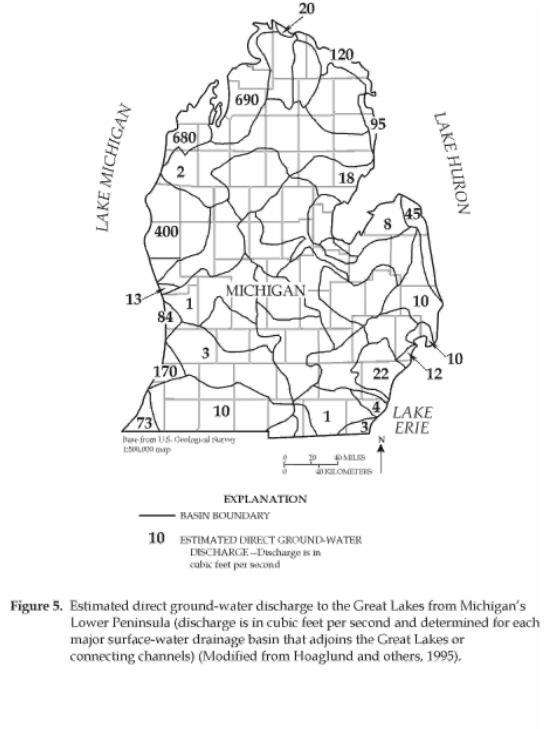
Hoaglund, J.R., Huffman, G.C., and Grannemann, N.G., 1995, Ground-water discharge to the Great Lakes and Great Lakes connecting channels from the Lower Peninsula of Michigan:
International Association for Great Lakes Research, Program with Abstracts, Spring meeting, 1995.
"Abstract"
"A steady-state, numerical model was developed to simulate ground-water flow in four regional aquifers in Michigan's Lower Peninsula as part of the U. S. Geological Survey Regional Aquifer-Systems Analysis program. The model treats Lakes Michigan, Huron, St. Clair, and Erie as well as the St. Clair and Detroit Rivers as constant-head boundaries. These boundaries represent three sides of the modeled area. Basin divides near the southern border of the Lower Peninsula were simulated as no-flow boundaries. Although the model was developed to quantify regional ground-water flow in the aquifer system, it can also be used to estimate ground-water discharge to the lakes and to the St. Clair and Detroit River connecting channels. Recharge rates were developed by analyzing streamflow, precipitation, and basin-characteristics data for 114 basins where streamflow is unregulated. Ground-water discharge to 2,000 stream segments also can be estimated in 44 major basins that incorporate nearly all of the perennial streams in the study area.
The MODFLOW computer code was used to calculate ground-water flow in the modeled area. Four layers were delineated so that each layer represents an aquifer. The model has about 106,000 active finite-difference cells in the uppermost layer. The equally spaced cells are 1 kilometer on each side. About 1,500 cells we needed to represent the Great Lakes shoreline and the river-channel boundaries. Because some of the aquifers contain saline water and brine, input to the model was adjusted to simulate flow of water with variable density."
By adding the direct ground-water discharge to Lake Michigan from values given in figure 5, the total simulated discharge rate is about 2,100 ft3/s. This discharge rate is much larger than estimates for the western shore of Lake Michigan.
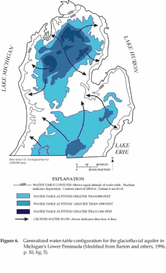
Barton, Gary, Mandle, R.J., and Baltusis, M.A., Jr., 1996, Predevelopment freshwater heads in the Glaciofluvial, Saginaw, and Marshall aquifers in the Michigan Basin: U.S. Geological Survey Open-File Report 95-319, 15 p.
Section titled: "Predevelopment Freshwater Heads in the Glaciofluvial Aquifer"
"The water-table map for the glaciofluvial aquifer (fig. 6) shows two areas of high water-table altitudes in which separate subregional flow systems exist: the Northern and Southern Uplands. Water-table altitudes in the Northern Uplands exceed 1,200 ft and are as much as about 1,000 ft in the Southern Uplands. The water table slopes away from the upland areas toward Lakes Michigan, Huron, and Erie and toward an elongated northeast-southwest depression in the water table across the Lower Peninsula. The depression is in the proglacial Grand River Valley, the site of the present day Grand, Maple and Saginaw Rivers. Generalized ground-water flow directions, inferred from this water-table map, show that water in the glacial deposits moves from upland areas to lowland areas and discharges to Lakes Michigan, Huron, and Erie and to stream tributaries to these lakes including the Grand, Maple, and Saginaw Rivers." (p. 9)
These data can be used to help evaluate the rates of direct ground-water discharge to the Great Lakes, but these calculations are not given in the report.
A few references, previously listed under the Lake Michigan section, also contain information about Lake Huron. For example, information for all of the Great Lakes and connecting channels surrounding Michigan's Lower Peninsula is included on figure 6 (Hoaglund and others, 1995). Discharge to Lake Huron from the Lower Peninsula based on data given in figure 5, is about 300 ft3/s.
Schertzer, W.M., Bennett, E.B., and Chiocchio, F., 1979, Water balance estimate for Georgian Bay in 1974: Water Resources Research, vol. 15 (1), p. 77-84.
Part of section titled "Water Balance"
"The assumption is made that groundwater contribution to the water balance is negligible."
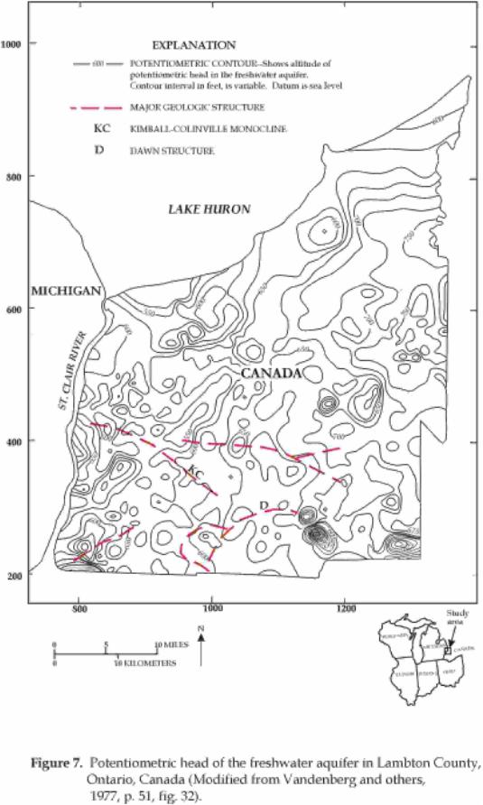
Vandenberg, A., Lawson, D.W., Charron, J.E., and Novakovic, B., 1977, Subsurface waste disposal in Lambton County, Ontario: Fisheries and Environment Canada, Inland Waters Directorate, Water Resources Branch, Technical Bulletin No. 90, 62 p.
Part of "Abstract"
"The major freshwater aquifer in the County is located at the bedrock-overburden contact. Its chemical water types and the data concerning its piezometric surface combine to show the direction of groundwater movement." (p. ix of Vandenberg and others, 1977 and fig. 7 of this report)
Lake Superior and St. Marys River
Only three published estimates of direct ground-water discharge to Lake Superior or the St. Marys River were found during this compilation. Gillespie and Dumouchelle (1989) estimated a discharge of 76 ft3/s for the St. Marys River. Appreciable quantities of ground water may discharge to the Lake from the United States side, but none have been quantified. For example, in a number of examples, ground-water flow in an outwash plain near Marquette, Mich. that covers about 150 mi2 and extends nearly to the Lake, may be as much as 50 ft3/s (Grannemann, 1984). Smaller outwash plains more distant from the lake also may be hydraulically connected to the lake (Vanlier and Deutsch, 1958; Handy and Twenter, 1985) but calculating rates of discharge to the lake from these outwash plains requires data on the hydraulic properties of the lakebeds, which is presently unknown. The eastern Upper Peninsula and the Keweenaw Peninsula (fig. 1) are the most likely sites where these outwash plains may be present and hydraulically connected to the Lake.
A water-budget analysis for the Lake Superior watershed in northeastern Minnesota indicated that "Although some underflow is probably moving into Lake Superior from the North Shore area, the amount is considered insignificant because of the low permeability of the aquifers" (Olcott and others, 1978).
Young and Skinner (1974) estimated that "underflow to Lake Superior averages 0.5 in/yr from the Wisconsin Lake Superior shoreline."
Lake St. Clair, St. Clair River, and Detroit River
Three reports are available where measured rates of seepage into the St. Clair River near Sarnia were estimated in conjunction with concerns about contaminated ground water discharging to the River (Mason and others, 1986; Lee, 1987; and Intera Technologies Ltd., 1987). However, the total ground-water discharge to the river was not estimated in any of these reports. The following two reports (Taylor and Cherkauer, 1987; Gillespie and Dumouchelle, 1989) do provide estimates for the St. Clair River, Lake St. Clair, and Detroit River.
Taylor, R.W. and Cherkauer, D.S., 1987, A geophysical and hydrological determination of the ground water flux through the bottom sediments of the upper connecting channels: Report to U.S. Environmental Protection Agency: University of Wisconsin, Milwaukee, Wisconsin, 57 p.
The results of various methods of estimating ground-water discharge to the upper Great Lakes connecting channels are listed below in a table from Taylor and Cherkauer (1987).
Table 1.Ground-water discharge to the Connecting Channels in the upper Great Lakes based on three methods (Taylor and Cherkauer, 1987, p. 47, Table 4).
[All discharges are in cubic feet per second and include flows from the United States and Canada.]
| River | Geophysical Method | Seepage Meters | U.S. Geological Survey Method |
|---|---|---|---|
| St. Clair River | 22.8 | 26 | 16 |
| Lake St. Clair | 31.3 | 41.3 | 33.6 |
| Detroit River | 28.2 | 19.3 | 47.8 |
| Total | 82.3 | 86.6 | 97.4 |
Gillespie, J.L., and Dumouchelle, D.H., 1989, Ground-water flow and quality near the upper Great Lakes connecting channels, Michigan: U.S. Geological Survey Water-Resources Investigations Report 88-4232, 82 p.
Part of "Abstract"
"Total ground-water discharge to the channels, by area, is estimated as follows: St. Marys area, 76 cubic feet per second; St. Clair area, 11 cubic feet per second; Lake St. Clair area, 46 cubic feet per second; and Detroit area, 54 cubic feet per second." (p. 1)
Haefeli, C.J., 1972, Groundwater inflow into Lake Ontario from the Canadian side: Department of the Environment, Inland Waters Branch, Scientific Series no. 9, 101 p.
Part of "Summary and Conclusions"
"The groundwater inflow into the Canadian side of Lake Ontario was computed in three different ways: (a) after the classic method (Darcy) using permeability values converted from specific capacity data of water wells situated in the shore belt area, the average hydraulic gradient of this region and the cross-sectional area along the shore; (b) after a numerical method developed by Freeze, and based on Laplace's equation, using ten representative profiles perpendicular to the shore, computing for each of them the distribution of the hydraulic potential and by means of a quantitative flow net, the groundwater flow; (c) after two methods, Methods A and B, using baseflow data but ignoring deep groundwater flow system; method A extrapolates the baseflow per unit area of the watersheds around the lake to the shore catchment discharging directly into Lake Ontario; method B uses the transmissibility values, T, computed from baseflow, the average water table slope and stream length of the various watersheds. T is extrapolated to the shore area and used with the shore length and the hydraulic gradient (from the classic method) to derive the groundwater inflow."
Table 2. Comparison of total direct ground-water discharge to Lake Ontario from the Canadian side computed using four methods (Haefeli, C.J., 1972, p. 63, table 28). [ft3/s, cubic feet per second]
| Method | Total flow (ft3/s) | Adjustments | Remarks |
|---|---|---|---|
| Classic (Darcy) | 51.6 | Add about 9 ft3/s for flow through overburden (hydraulic gradient). | Values on low side, probably too much emphasis on overburden thickness in relation to bedrock permeability. |
| Numerical | 63.7 | None. | Same as classic. |
| Baseflow A | 118.2 | Add about 20 percent for area between Kingston and Iroquois. | Rough estimation. |
| Baseflow B | 21.8 | Same as baseflow A above. | Probably too low (stream length percent). |
Discharge from Regional Ground-Water Flow
The regional rate of ground-water discharge to the Great Lakes is less certain and much harder to estimate than the near-shore discharge rate. Most work on regional flow systems has been done to assess the effects of pumping deep aquifers on the western shore of Lake Michigan. Only a few of these studies made estimates of the amount of water induced from or to the lake-aquifer systems have been made in specific studies. Work in the Green Bay area by the USGS (Conlon, 1998) used Lake Michigan as a model boundary to simulate ground-water flow. Similar regional models were done for large parts of western Lake Michigan for the Upper Midwest Regional Aquifer-Systems Analysis (RASA) study.
The Illinois State Geological Survey (Cartwright and others, 1979) measured hydraulic gradients across the southern part of Lake Michigan to estimate fluxes farther off shore, which are probably part of the regional discharge of ground water to the lakes. The upward gradients in deep parts of Lake Michigan, in conjunction with geochemical evidence for ground-water discharge from lake sediments, emphasizes the need to understand the relation of regional flow for making estimates of ground-water discharge to the lakes.
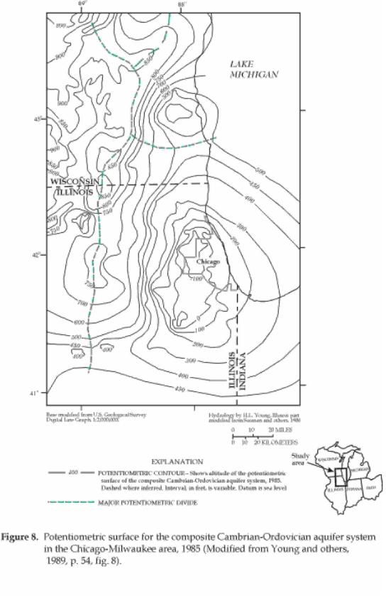
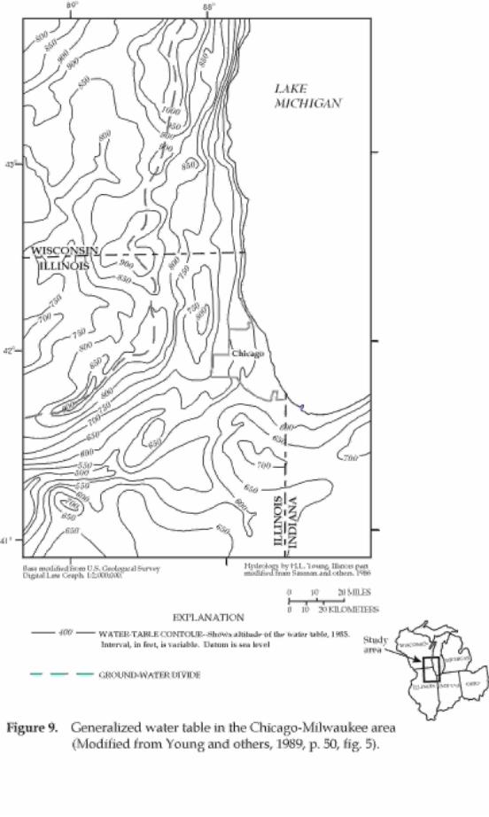
Young, H.L., MacKenzie, A.J., and Mandle, R.J., 1989, Simulation of ground-water flow in the Cambrian-Ordovician aquifer system in the Chicago-Milwaukee area of the northern midwest: in AWRA Monograph Series No. 13, edited by Swain and Johnson, p. 39-72.
Part of "Summary"
"A digital model of the Chicago-Milwaukee area was developed to simulate three-dimensional ground-water flow in the Cambrian-Ordovician aquifer system. The aquifer system was modeled as three aquifer layers (primarily sandstone), each overlain by confining units of various amounts of shale, siltstone, and dolomite. The flow model was used to simulate predevelopment steady-state flow conditions, and stressed conditions from 1865-1985. The model was calibrated by matching simulated potentiometric surfaces and head declines with measured and estimated potentiometric surfaces and head declines. A comparison of these composite heads for the Cambrian-Ordovician aquifer system shows that the mean of absolute values of residuals at 1,554 cells was 13.8 ft. For developed conditions, a similar comparison was made for 1961, 1980, and 1985. The mean of absolute values of residuals for these years was 32.9, 30.5, and 32.2 ft, respectively. Overall trends in simulated and measured or estimated head decline compare favorably for locations in Wisconsin, simulated heads are generally within 30 ft of measured or estimated heads. The measured or estimated heads are within 50 ft of simulated heads at most of the Illinois locations.
The simulated predevelopment ground-water budget shows that recharge to the Cambrian-Ordovician aquifer system occurs most readily where it subcrops beneath glacial drift. In subcrop areas; 74.0 ft3/ s recharges the aquifer system, whereas 85.5 ft3/s discharges from the aquifer system to the drift. Recharge through the Maquoketa confining unit is 31.7 ft3/s, where it is thin or subcrops beneath drift. Where it is overlain by Silurian and Devonian rocks, 5.1 ft3/s recharges the aquifer system. Discharges to the overlying drift and Silurian-Devonian rocks through the Maquoketa confining unit are 12.0 and 11.6 ft3/s, respectively. Overall, recharge to the bedrock aquifers in the area totaled 129 ft3/s--a rate that was balanced by discharge from these aquifers. (p. 69)
The simulated 1985 ground-water budget shows the influence of human activities on the hydrologic system. Induced recharge to the bedrock aquifers totaled 467 ft3/s, and water derived from storage (as a result of withdrawals) was 127 ft3/s. This was balanced by 535 ft3/s withdrawn by pumping and 62 ft3/s that discharges naturally to the overlying drift aquifer. (p. 69)
Potentiometric surfaces and generalized directions of ground-water flow for the Cambrian-Ordovician aquifer and the water-table in the Chicago-Milwaukee area are shown in figures 8 and 9. The water-budget estimates calculated in model simulation helped evaluate the relations between regional flow in deep aquifers and Lake Michigan, which is a boundary in the model. As indicated above, the total simulated amount of recharge induced to bedrock aquifers is 467 ft3/s; however, the amount induced from Lake Michigan is not quantified in the report.
Conlon, T.D., in press, Hydrogeology and simulation of ground-water flow in the sandstone aquifer, Northeastern Wisconsin: U.S. Geological Survey Water-Resources Investigations Report, 52 p.
Conlon reports model results for a model that includes most of the Green Bay area and the Fox River valley in Wisconsin. Discharge of about 15 ft3/s is simulated for Lake Michigan and Green Bay.
Eberts, S.M.,in press, Geohydrology and regional flow in the midwestern basins and arches aquifer system in parts of Indiana, Ohio, Illinois, and Michigan: U.S. Geological Survey Professional Paper 1423-C, 68 p.
Part of section titled: "Simulated Regional Ground-Water Flow".
"Discharge attributed to regional ground-water flow in these bedrock units is a very small percentage of total ground-water discharge to the Ohio River; discharge directly to the Ohio River from the Ohio Valley Aquifer along the boundary of the modeled area has been computed at approximately 1,400 Mgal/d (2,166 ft3/s). Less than one percent of the regional ground-water flow, represented in the model, discharges to Lake Erie." (p. 62)
Kolak, J.J., Long, D.T., Callender, E.C., and Grannemann, N.G., in preparation for submission to journal, Geochemical evidence of natural, saline water input to the Great Lakes: 10 p.
"Abstract"
"Porewaters from Great Lakes' sediments were analyzed to determine if the lakes are receiving natural input of saline water derived from Michigan Basin brines. Dissolved chloride concentrations are used as the primary indicator of the input; elemental ratios are used to deduce the origin of the saline water. Vertical profiles of porewater-chloride concentrations show the potential for the upward migration of saline water into the overlying water column. Elemental ratios identify brine as the source for salinity. Saline water may be coming from multiple geologic formations and may be transported via topographically driven ground-water flow, even at considerable depths with the Michigan Basin." (p. 1) (Chemical evaluation of water from Great Lakes sediment helps evaluate the relation between regional ground-water flow and lake water.)
Discharge Focusing on Embayments
Ground-water discharge to embayments have not been extensively researched for the Great Lakes. However, these estimates need to be understood and evaluated because the potential for ground-water discharge to embayments and mouths of large streams may be an appreciable amount of flow that has been under-represented in some previous estimates.
Cherkauer, D.S., and McKereghan, P.F., 1991, Ground-water discharge to lakes: focusing in embayments: Ground Water, vol. 29 (1), p. 72-80.
"Conclusions"
"Ground-water discharge to Green Bay and Lake Michigan from the Door Peninsula is spatially variable. The total discharge offshore from a given shoreline location (QT) has been digitally simulated. These simulated values agree well with field measurements and flow-net calculations. They show that QT is influenced by both aquifer properties and coastal configuration.
Of nearly 66,000 m3/day (27 ft3/s) of ground water which discharges directly to Green Bay and Lake Michigan, 60% goes to the latter because aquifer transmissivity is higher along the Peninsula's east coast. QT also increases toward the northeast along both coasts because hydraulic conductivity is higher there.
The dominant control of the distribution of QT in the study area, however, is coastal configuration. Both horizontal and vertical penetration of the lake into the aquifer in bays induce a convergence of ground-water flow toward the bay. The result is an amplification of QT in bays in the study area by as much as 500% over that which would be expected if the coast were straight. The amplification is equally influenced by the horizontal and vertical penetration in the study area. The validity of the relation presented outside of the study area is not known." (p. 80) (Reprinted with the permission of Ground Water Publishing Company. Copyright 1998.)
Bradbury, K.R., 1982, Hydrologic relationships between Green Bay of Lake Michigan and onshore aquifers in Door County, Wisconsin: Ph.D. Dissertation, Univ. of Wisconsin, Madison, Wisconsin., 276 p.
Part of "Conclusions"
"The magnitude of groundwater discharge to Green Bay may be greater than previously assumed. Estimates of direct groundwater discharge to the bay from the study area, made using five different techniques, range from 3.0 to 10.9 ft3/s or 0.8 to 2.7 ft3/s per linear mile of shoreline. Assuming that groundwater conditions around Green Bay are uniform, and are similar to conditions in the study area, the direct groundwater contribution to Green Bay ranges from 170 to 613 ft3/s or from 6 to 20% of the total surface water contribution....." (p. 243).
Twenter, F.R., Cummings, T.R., and Grannemann, N.G., 1985, Ground-water contamination in East Bay Township, Michigan: U.S. Geological Survey Water-Resources Investigations Report 85-4064, 63 p.
Model simulations indicate that ground-water discharge to Grand Traverse Bay is about 5 ft3/s from an 8 mi2 study area. If this rate is representative of the entire bay (the entire bay is about 160 mi2), a conservative estimate of the total direct ground-water discharge to the Bay would be about 100 ft3/s.
Although the total amount of direct ground-water discharge to the Great Lakes is not known, many local and a few regional estimates of direct recharge rates have been made. This report reviews the published estimated rates to compare and evaluate this unknown part of the water budget for the Great Lakes. A summary of the estimated discharge rates from the references is listed below in table 3. A review of table 3 indicates that of all the Great Lakes, the highest estimated rates of direct ground-water discharge are for Lake Michigan. Total estimated ground-water discharge to Lake Michigan ranges from 800 to 6,700 ft3/s (Bergstrom and Hansen, 1962; Cartwright and others, 1979). These two extreme values were the first estimates of direct ground-water discharge made for Lake Michigan and were based on few data.
However, discharge estimates in this area do not include a regional component of ground-water flow that could raise estimated discharge rates. Ground water is discharged to Lake Michigan at the highest rate along the northeastern shore of the Lake. Geochemical evidence is available for regional ground-water flow to Lake Michigan, but no discharge rates have been estimated except for Cartwright and others (1979). They calculated 300 ft3/s of direct ground-water discharge from regional sources for all of Lake Michigan.
Based on all available data, a general estimate for total direct ground-water discharge to Lake Michigan from the various States surrounding the Lake was determined. These generalized rates are as follows: 125 ft3/s for Wisconsin (Cherkauer and Hensel, 1986), 70 ft3/s for Illinois (based on similar hydrogeologic setting in Wisconsin), 50 ft3/s for Indiana (generalized from Meyer and Tucci, 1979), 2,000 ft3/s for Michigan's Lower Peninsula (Hoaglund and others, 1995), 125 ft3/s for Michigan's Upper Peninsula (based on a similar hydrogeologic setting in Door Peninsula, Cherkauer and Hensel, 1986), and 300 ft3/s for regional discharge (Cartwright and others, 1979). The total (2,670 ft3/s) for Lake Michigan is considerably less than Cartwright and others (1979) estimate (6,700 ft3/s) but more than Bergstrom and Hansen (1962) estimated (800 ft3/s). For comparison, average discharge of the St. Clair River at Port Huron was about 187,000 ft3/s in 1995. Insufficient data are available to make similar estimates for the remaining Great Lakes, but estimated rates from known studies are much smaller than those for Lake Michigan. Ground-water resources are highly variable in the Great Lakes Basin (Great Lakes Basin Commission, 1975). Therefore, it should not be surprising that direct ground-water discharge to the Lakes also varies considerably with the highest estimated rates for Lake Michigan.
Table 3. Summary of estimated
rates of direct ground-water discharge to the Great Lakes based on published
values
(ft3/s, cubic feet per second; --, not applicable; km2, square kilometers)
| Reference | Segment of Great Lakes | Discharge (ft3/s) | Basis for estimate and comment |
|---|---|---|---|
|
Bergstrom and Hansen, 1962
|
Lake Michigan | 800 | -- |
|
Cartwright and Others, 1979
|
Lake Michigan | 6,700 | near shore + regional flow |
|
Cherkauer and Hensel, 1986
|
Wisconsin shore Lake Michigan | 93-169 | seepage meters + geophysics |
|
Nauta, 1987
|
Door Peninsula to Lake Michigan | 8.4 | model output |
|
Meyer and Tucci, 1979
|
Southern Lake Michigan | 3.7 | from 4 km2 area |
|
Hoaglund and others, 1995
|
Eastern shore Lake Michigan | 2,000 | model output |
|
Hoaglund and others, 1995
|
Western shore Lake Huron | 300 | model output |
|
Gillespie and Dumouchelle, 1989
|
St. Marys River | 76 | -- |
|
Grannemann, 1984
|
Lake Superior | 50 | 150 mi2 area |
|
Taylor and Cherkauer, 1987
|
Lake St. Clair and channels | 82 | without bedrock |
|
Gillespie and Dumouchelle, 1989
|
Lake St. Clair and channels | 111 | includes bedrock |
|
Hafelli, 1972
|
North shore Lake Ontario | 22-118 | 4 methods |
|
Bradbury, 1982
|
Green Bay | 170-613 | for whole Bay |
|
Nauta, 1987
|
Green Bay from Door Peninsula | 6.4 | model output |
|
Twenter and others, 1985
|
Grand Traverse Bay | 5 | model for 8 mi2 |
Anderson, R.H., 1987, Geophysical measurement and computer modeling of ground water flux through lake sediments: Lake St. Clair, Michigan/Ontario: M.S. Thesis, Department of Geosciences, University of Wisconsin, Milwaukee, 140 p. (unpublished)
Barton, Gary, Mandle, R.J., and Baltusis, M.A., Jr., 1996, Predevelopment freshwater heads in the Glaciofluvial, Saginaw, and Marshall aquifers in the Michigan Basin: U.S. Geological Survey, Open-File Report 95-319, 15 p.
Barwell, V.K. and Lee, D.R., 1981, Determination of horizontal-to-vertical hydraulic conductivity ratios from seepage measurements on lake beds: Water Resources Research, vol. 17(3); p. 570.
Bergstrom, R.E. and Hansen, C.F., 1962, Ground water supplies in Wisconsin and Illinois adjacent to Lake Michigan. In: H.J. Pincus (Editor), Symposium on Great Lakes Basin, Chicago Meeting of the Am, Assoc. Adv. Sci.
Bradbury, K.R., 1982, Hydrologic relationships between Green Bay of Lake Michigan and onshore aquifers in Door County, Wisconsin: Ph.D. Dissertation, Univ. of Wisconsin, Madison, Wisconsin., 276 p.
Bradbury, K.R., and Taylor, R.W., 1985, Determination of the hydrogeologic properties of lakebeds using offshore geophysical surveys: Ground Water, vol. 22, no. 6, p. 690-695.
Bues, D.J., 1983, The hydrologic relationship between Lake Michigan and a shallow dolomite aquifer at Mequon, WI. M.S. Thesis, Department of Geosciences, University of Wisconsin, Milwaukee, 211 p. (unpublished)
Cartwright, Keros, Hunt, C.S., Hughes, G.M., and Brower, R.D., 1979, Hydraulic potential in Lake Michigan bottom sediments: Elsevier Scientific Publishing Co., Amsterdam, Journal of Hydrology, vol. 43, p. 67-78.
Cherkauer, D.S., and Hensel, B.R., 1986, Groundwater flow into Lake Michigan from Wisconsin: Journal of Hydrology, vol. 84(3/4), p. 261-271.
Cherkauer, D.S., and McBride, J., 1988. A remotely-operated seepage meter for use in large lakes and rivers: Ground Water, vol. 26(2), p. 165-171.
Cherkauer, D.S., and McKereghan, P., 1987, Seismic lines run along west side of Door County, Wisconsin, Progress Report to Wisconsin Dept. of Natural Resources.
Cherkauer, D.S., and McKereghan, P.F., 1991, Ground-water discharge to lakes: focusing in embayments: Ground Water, vol. 29 (1), p. 72-80.
Cherkauer, D.S., McKereghan, and Schalch, L.H., 1992, Delivery of chloride and nitrate by ground water to the Great Lakes: Case study for the Door Peninsula, Wisconsin: Ground Water, vol. 30(6), p. 885-894.
Cherkauer, D.S., and Nader, D.C., 1989, Distribution of groundwater seepage to large surface-water bodies: the effect of hydraulic heterogeneities: Journal of Hydrology, vol. 109(1/2), p. 151-165.
Cherkauer, D.S. Taylor, R.W. and Bradbury, K.R., 1987, Relation of lake bed balance to geoelectrical properties: Ground Water, vol. 25(2), p. 135-140.
Cherkauer, D.S., and Zvibleman, B., 1981, Hydraulic connection between Lake Michigan and a shallow ground-water aquifer: Ground Water, vol. 19, no. 4, p. 376-381.
Conlon, T.D., 1998, Hydrogeology and simulation of ground-water flow in the sandstone aquifer, Northeastern Wisconsin: U.S. Geological Survey Water-Resources Investigations Report 97-4096, 52 p.
Craig, K., 1989, Hydrogeology of the rock-sediment-lake system in Door Co., Wisconsin: M.S. Thesis, Department of Geosciences, University of Wisconsin, Milwaukee (unpublished)
Eberts, S.M., in press, Geohydrology and regional flow in the midwestern basins and arches aquifer system in parts of Indiana, Ohio, Illinois, and Michigan: U.S. Geological Survey Professional Paper 1423-C, 68 p.
Fleck, W.B., and McDonald, M.G., 1978, Three-dimensional finite-difference model of ground-water system underlying the Muskegon County wastewater disposal system, Michigan: U.S. Geological Survey Journal of Research, vol. 6, p. 307-318.
Fraser, G.S. and Hester, N.C., 1974, Sediment distribution in a beach ridge complex and its application to artificial beach replenishment. Illinois State Geol. Surv., Environ. Geol. Note 67, 26 p.
Gillespie, J.L., and Dumouchelle, D.H., 1989, Ground-water flow and quality near the upper Great Lakes connecting channels, Michigan: U.S. Geological Survey Water-Resources Investigations Report 88-4232, 82 p.
Grannemann, N.G., 1984, Hydrogeology and effects of tailings basins on the hydrology of Sands Plain, Marquette County, Michigan: U.S. Geological Survey Water-Resources Investigations Report 84-4114, 98 p.
Great Lakes Basin Commission, 1975, Great Lakes Basin Framework Study, 105 p., 23 Appendices.
Haefeli, C.J., 1972, Groundwater inflow into Lake Ontario from the Canadian side: Department of the Environment, Inland Waters Branch, Scientific Series no. 9, 101 p.
Handy, A.H., and Twenter, F.R., 1985, Water resources of Pictured Rocks National Lakeshore, Michigan: U.S. Geological Survey Water-Resources Investigations Report 85-4103, 41 p.
Hensel, B., 1984, The spatial distribution of hydrogeologic conditions along the Lake Michigan shoreline in Wisconsin, Unpublished M.S.
Thesis, Univ. of Wisconsin-Milwaukee, Milwaukee, Wisconsin., 171 p.
Hoaglund, J.R., Huffman, G.C., and Grannemann, N.G., 1995, Ground-water discharge to the Great Lakes and Great Lakes connecting channels from the Lower Peninsula of Michigan: International Association for Great Lakes Research, Program with Abstracts, Spring meeting, 1995.
Hough, J.L., 1958, Geology of the Great Lakes: University of Illinois Press, Urbana, Illinois, 313 p.
Intera Technologies Ltd, 1987, Study of the fresh water aquifer and deep geologic formations in the Sarnia Area, Ontario, Prepared for Ontario Ministry of the Environment, Ontario, Canada, 24 p.
John, P.J. and Lock, M.A., 1977, The spatial distribution of groundwater discharge into the littoral zone of a New Zealand lake: Journal of Hydrology, vol. 33, p. 391-395.
Kammerer, P.A., 1995, Ground-water flow and quality in Wisconsin's shallow aquifer system: U.S. Geological Survey Water-Resources Investigations Report 90-4171, 42 p.
Kolak, J.J., Long, D.T., Callender, E.C., and Grannemann, N.G., in preparation, Geochemical evidence of natural, saline water input to the Great Lakes: Journal article, 10 p.
Lee, D.R., 1985, Method for locating sediment anomalies in lakebeds that can be caused by groundwater flow: Journal of Hydrology, vol. 79, p. 187-193.
Lee, D.R., 1987, Sediment Survey of the St. Clair River near Sarnia: Chalk River Nuclear Laboratories, Chalk River, Ontario, Canada.
Lee, D.R., Cherry, J.A. and Pickens, J.F., 1980, Groundwater transport of a salt tracer through a sandy lake bed: Limnology and Oceanography, vol. 25(l) p. 45-61.
Lineback, J.A. and Gross, D.L., 1972, Studies of Lake Michigan bottom sediments, Depositional patterns, facies, and trace element accumulation in the Waukegan Member of the Late Pleistocene Lake Michigan Formation in southern Lake Michigan: Illinois State Geological Survey Environmental Geolology Note 58, 25 p.
Lineback, J.A., Gross, D.L. and Meyer, R.P., 1972, Geologic cross sections derived from seismic profiles and sediment cores from southern Lake Michigan: Illinois State Geological Survey Environmental Geology Note 54, 43 p.
Mason, S., Sklash, M.G., Scott, S. and Pugsley, C., 1986, An assessment of seepage of groundwater into the St. Clair River near Sarnia, Ontario, Canada: Final Report for Environment Canada, Great Lakes Institute, University of Windsor, Ontario, 175 p.
McBride, M.S., and Pfannkuch, H.O., 1975, The distribution of seepage within lakebeds: U.S. Geological Survey Journal of Research, vol. 3, no. 5, p. 505-512.
Meyer, William, and Tucci, Patrick, 1979, Effects of seepage from fly-ash settling ponds and construction dewatering on ground-water levels in the Cowles Unit, Indiana Dunes National Lakeshore, Indiana: U.S. Geological Survey Water-Resources Investigations Report 78-138, 95 p.
Morrison, M.B., 1981, Evaluation of groundwater-lake interaction in the Point Beach State Forest area, Manitowoc County, Wisconsin. Unpublished M.S. Thesis, Univ. of Wisconsin-Milwaukee, Milwaukee, Wisconsin., 182 p.
Nauta, Robert, 1987, A three-dimensional ground-water flow model of the Silurian Dolomite aquifer of Door County, Wisconsin: University of Wisconsin, Unpublished M.S. Thesis, Madison, Wisconsin.
Olcott, P.G., Ericson, D.W., Felsheim, P.E., and Broussard, W.L., 1978, Water resources of the Lake Superior Watershed, northeastern Minnesota: U.S. Geological Survey Hydrologic Investigations Atlas HA-582, 1 plate.
Pfannkuch, H.O. and Winter, T.C, 1984, Effect of anisotropy and groundwater system geometry on seepage through lakebeds: 1. Analog and dimensional analysis: Journal of Hydrology, vol. 75, p. 213-237.
Quigley, R.M. and Ogumbadejo, T,A., 1976, Till geology, mineralogy and geotechnical behaviour In:R.F. Leggett (Editor), Glacial Till: an Inter-Disciplinary Study: Royal Society of Canada Special Publication 12, p. 336-345.
Rose, H.G. and Smith, H.F., 1957, A method for determining permeability and specific capacity from effective grain size, Illinois State Water Survey, Circular No. 59.
Rose, W.J., 1987, Water resources of the Apostle Islands National Lake Shore: U.S. Geological Survey Water-Resources Investigations Report 87-4220, 44 p.
Rovey, C.W., 1983, Computer modeling of the interaction between Lake Michigan and the dolomite aquifer at Mequon, Wisconsin: Unpublished M.S. Thesis, University of Wisconsin-Milwaukee, Milwaukee, Wisconsin, 271 p.
Ruch, R.R., Kennedy, E.J. and Shimp, N.F., 1970, Studies of Lake Michigan bottom sediments, 4. Distribution of arsenic in unconsolidated sediments from southern Lake Michigan: Illinois State Geological Survey Environmental Geology Note 37, 16 p.
Schertzer, W.M., Bennett, E.B., and Chiocchio, F., 1979, Water balance estimate for Georgian Bay in 1974: Water Resources Research, vol. 15 (1), p. 77-84.
Sellinger, C.E., 1995, Groundwater flux into a portion of eastern Lake Michigan: International Association of Great Lakes Research, Journal of Great Lakes Research, vol. 21, p. 53-63.
Schleicher, J.A. and Kuhn, J.K., 1970, Studies of Lake Michigan bottom sediments, Phosphorous content in unconsolidated sediments from southern Lake Michigan: Illinois State Geological Survey Environmental Geology Note 39, 15 p.
Shimp, N.F., Leland, H.U. and White, W.A., 1970, Studies of Lake Michigan bottom sediments, Distribution of major, minor, and trace constituents in unconsolidated sediments from southern Lake Michigan: Illinois State Geological Survey Environmental Geology Note 32, 19 p.
Shimp, N.F., Schleicher, J.A., Ruch, R.R., Heck, D.B. and Leland, H.V., 1971, Studies of Lake Michigan bottom sediments, Trace element and organic carbon accumulation in the most recent sediments of southern Lake Michigan: Illinois State Geological Survey Environmental Geology Note 41, 25 p.
Sherill, M.G., 1978, Geology and ground water in Door County, Wisconsin, with emphasis on contamination potential in the Silurian dolomite: U.S. Geological Survey Water Supply Paper 2047, 38 p.
Skinner, E.L. and Borman, R.C., 1973, Water resources of Wisconsin-Lake Michigan basin: U.S. Geological Survey Hydrologic Atlas 432, 4 sheets.
Sklash, M.G., Mason, S., Scott, S. and Pugsley, C., 1986, An investigation of the quantity, quality and sources of groundwater seepage into the St. Clair River near Sarnia, Ontario, Canada: Water Pollution Research Journal of Canada, vol. 21(3): p. 351-367.
Taylor, R.W. and Cherkauer, D.S., 1984, The application of combined seismic and electrical measurements to the determination of the hydraulic conductivity of a lake bed: Ground Water Monitoring Review, vol. 4(4): p. 75.
Taylor, R.W. and Cherkauer, D.S., 1987, A geophysical and hydrological determination of the ground water flux through the bottom sediments of the upper connecting channels: Report to U.S. Environmental Protection Agency: University of Wisconsin-Milwaukee, Milwaukee, Wisonsin, 57 p.
Taylor, R,W., Cherkauer, D.S. and Anderson, M.P., 1987, Measurement of the interaction between Lake Michigan and the ground water of Wisconsin: Progress Report to University of Wisconsin Sea Grant Institute, 20 p.
Thompson, D.B., 1981, Hydrogeology of the Niagara Dolomite aquifer at Wind Point, WI, and its interaction with Lake Michigan. M.S. Thesis, Department of Geosciences, University of Wisconsin-Milwaukee, Milwaukee, Wisconsin 108 p. (unpublished)
Twenter, F.R., Cummings, T.R., and Grannemann, N.G., 1985, Ground-water contamination in East Bay Township, Michigan: U.S. Geological Survey Water-Resources Investigations Report 85-4064, 63 p.
Vandenberg, A., Lawson, D.W., Charron, J.E., and Novakovic, B., 1977, Subsurface waste disposal in Lambton County, Ontario: Fisheries and Environment Canada, Inland Waters Directorate, Water Resources Branch, Technical Bulletin No. 90, 62 p.
Vanlier, K.E., and Deutsch, M., 1958, Reconnaissance of the ground-water resources of Chippewa County, Michigan: Michigan Department of Conservation, Geological Survey Division, Progress Report 17, 56 p.
Visocky, A.P., 1977, Hydrologic study of Illinois Beach State Park: Illinois State Water Survey, Circular 128, 48 p.
Walton, W.C. and Drescher, F.C., W.J., 1953, Groundwater conditions in the Milwaukee-Waukesha area, Wisconsin: U.S. Geological Survey Water Supply Paper 1229, 96 p.
Watson, L.R., Shedlock, R.J., Banaszak, K.J., Arihood, L.D., and Doss, P.K., 1989, Preliminary analysis of the shallow ground-water system in the vicinity of the Grand Calumet River/Indiana Harbor Canal, Northwestern Indiana: U.S. Geological Survey Open-File Report 88-492, 45 p.
Winter, T.C., 1976, Numerical simulation analysis of the interaction of lakes and ground water: U.S. Geological Survey Professional Paper 1001, 45 p.
Winter, T. C., 1983, The interaction of lakes with variably saturated porous media: Water Resources Research, vol. 19 (5): p. 1203-1218.
Winter, T.C., 1986, Effect of ground water recharge on configuration of the water table beneath sand dunes and on seepage in lakes in the sandhills of Nebraska, USA: Journal of Hydrology, vol. 96, p. 221-237.
Winter, T.C., and Pfannkuch, H.O., 1984, Effect of anisotropy and groundwater system geometry on seepage through lake beds: Numerical simulation analysis: Journal of Hydrology, vol. 75, p. 239-253.
Woessner, W.W. and Sullivan, K.E., 1984, Results of seepage meter and mini-piezometer study, Lake Mead, Nevada: Ground Water, vol. 22(5) p. 561-568.
Young, H.L., MacKenzie, A.J., and Mandle, R.J., 1989, Simulation of ground-water flow in the Cambrian-Ordovician aquifer system in the Chicago-Milwaukee area of the northern midwest: in AWRA Monograph Series No. 13, edited by Swain and Johnson, p. 39-72.
Young, H.L, and Skinner, A.L., 1974, Water resources of Wisconsin-Lake Superior Basin: U.S. Geological Survey, Hydrologic Atlas 524, 3 sheets.
Zager, J. P., 1981, The interaction of surface and groundwater in Lower Nashotah Lake, Waukesha Co., Wisconsin: Unpublished M.S. Thesis, Department of Geosciences, University of Wisconsin, Milwaukee, 150 p.