
Water Resources of Michigan
Visualization of Drifting Buoy Deployments on Upper Detroit River within the Great Lakes Waterway from August 28-30, 2001
US Geological Survey Open-File Report 02-1
Lansing, Michigan 2002
| U.S. DEPARTMENT OF THE INTERIOR GALE NORTON, Secretary U.S. GEOLOGICAL SURVEY Charles G. Groat, Director |
Prepared in cooperation with the Michigan Department of Environmental Quality, Source Water Assessment Program Detroit Water and Sewerage Department, and the American Water Works Association Research Foundation |
| Any use of trade, product, or firm names in this publication is for descriptive purposes only and does not imply endorsement by the U.S. Government. | |
Long Version available in Web (HTML) format at:
http://mi.water.usgs.gov/pubs/OF/OF02-1/OF02-1LW.php
Contents
FIGURES
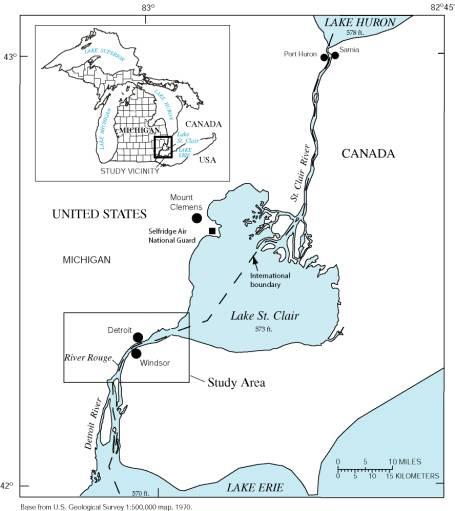
1. Map showing St. Clair-Detroit River Vicinity
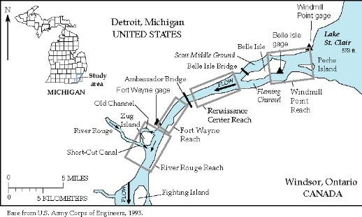
2. Map showing selected reaches in the Detroit River upstream from Fighting Island.
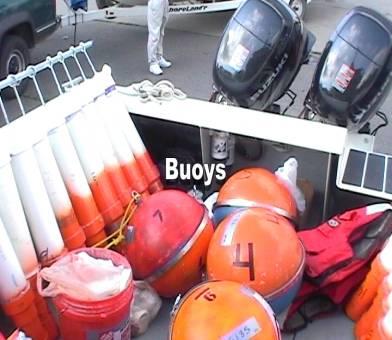
3. Photograph showing cylindrical and spherical buoys used in Detroit River deployments.
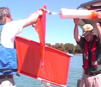
4. Photograph showing drogue attached to a cylindrical buoy to reduce effects of wind on buoy movements.
5. Photograph showing crew members from Detroit Water and Sewerage Department, Environment Canada,
and U.S. Geological Survey preparing to deploy drifting buoys on Detroit River.
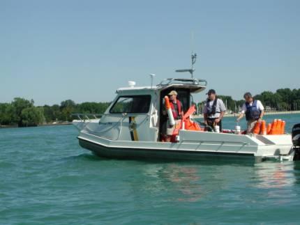
6. Photograph showing buoy cluster deployment on Detroit River upstream from the Renaissance Center,
Detroit, Michigan.
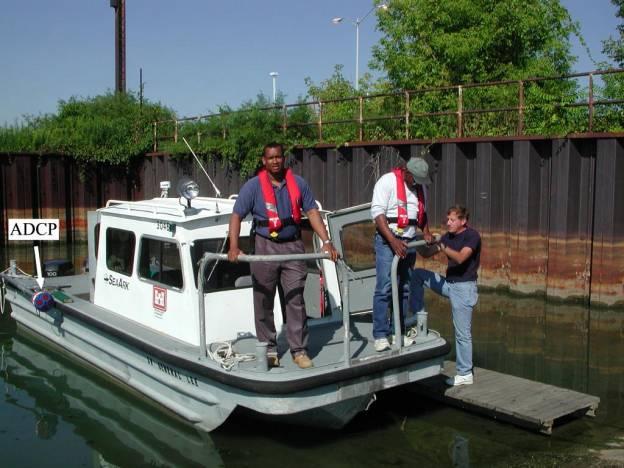
7. Photograph showing U.S. Army Corps of Engineers and Michigan Department of Environmental Quality
Staff Preparing for Flow Measurements on Detroit River using an Acoustic Doppler
Current Profiler (ADCP)
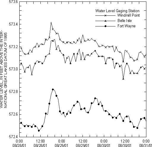
8. Graph showing water levels at gaging stations on upper Detroit River from August 28-30,
2001.
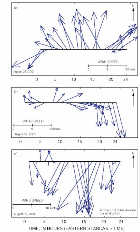
9. Graph showing wind data from Selfridge Air National Guard Base near Mount Clemens, Michigan
10. Map containing links for animations of buoy deployments on Detroit River upstream of Fighting
Island.
Tables
1. Timing of buoy releases on Detroit River
2. Flow measurements during buoy deployments on Detroit River
Tables-Appendix
CONVERSION FACTORS, ABBREVIATIONS, AND VERTICAL DATUM
| For additional information write to:
|
Copies of this report can be purchased from:
|
CONVERSION FACTORS, ABBREVIATIONS, AND VERTICAL DATUM
|
Multiply
|
By
|
To obtain
|
|---|---|---|
|
Length
|
||
|
inches (in)
|
25.4
|
millimeters (mm) |
|
International feet (ft)
|
0.3048 (exactly)
|
meters (m) |
|
mile (mi)
|
1.609
|
kilometer (km) |
|
Speed
|
||
|
knot
|
1.851
|
kilometers per hour (km/hr) |
|
Area
|
||
|
square mile (mi2)
|
2.59
|
square kilometer (km2) |
|
acre (ac)
|
0.4047
|
hectare (ha) |
|
Flow
|
||
|
cubic foot per second (ft3/s)
|
0.02832
|
cubic meter per second (m3/s) |
|
gallon (gal)
|
3.785
|
liter (L) |
|
Mass
|
||
|
pound (lb)
|
0.4536
|
kilograms (kg) |
Temperature in degrees Celsius (°C) can be converted to degrees Fahrenheit (°F) by the following equation:
°C = (°F-32)/1.8
Vertical Datum: The vertical datum currently used throughout the Great Lakes
is the International Great Lakes Datum of 1985 (IGLD 1985), although references
to the earlier datum of 1955 are still common. This datum is a dynamic height
system for measuring elevation, which varies with the local gravitational force,
rather than an orthometric system, which provides an absolute distance above
a fixed point. The primary reason for adopting a dynamic height system within
the Great Lakes is to provide an accurate measurement of potential hydraulic
head. The reference zero for IGLD (1985) is a tide gage at Rimouski, Quebec,
which is located near the outlet of the Great Lakes-St. Lawrence River system.
The mean water level at the Rimouski, Quebec gage approximates mean sea level.
Citation:
Back to Main Publications List
Back to USGS, WRD Michigan Home Page

![]() U.S. Department of the Interior |
U.S. Geological Survey
U.S. Department of the Interior |
U.S. Geological Survey
URL:
Page Contact Information: Webmaster([email protected])
Page Last Modified: Last modified: January 03 2017 11:07:40.