Water Resources of Michigan
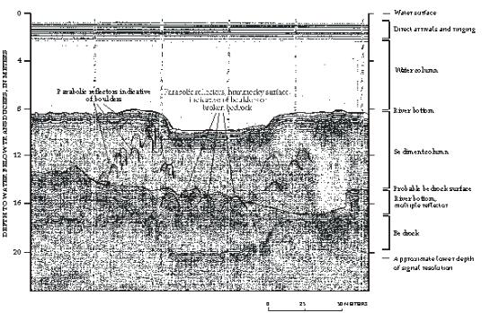
Continuous Seismic-Reflection Profiling near Grassy Island, Wyandotte Unit of Shiawassee National Wildlife Refuge, Wyandotte, Michigan
US Geological Survey Administrative Completion Report for WRD Reimbursable Agreement No. 8-4426-06000 of USFWS Parent Project No. 14-48-0003-97-905, DCN#1448-30181-97-N344, Unofficial publication #ACR97-01
Lansing, Michigan 1997
By: Michael J. Sweat
 |
|
| Prepared for U.S. Fish and Wildlife | |
| By Michael J. Sweat U.S. Geological Survey Water Resources Division 6520 Mercantile Way, Suite 5 Lansing, MI 48911-5991 |
Any use of trade, product, or firm names in this publication is for descriptive purposes only and does not imply endorsement by the U.S. Government. |
|
(Determination of chemical concentrations of selected metals and inorganic and organic compounds at selected sites in the sediments and ground water on and near Grassy Island, Wyandotte National Wildlife Refuge, Detroit River, Wyandotte, Michigan) |
|
Conversion Factors, Abbreviated Water Quality Units, and Vertical Datum
Contents
FIGURES
Maps showing:
| Multiply | By Length | To Obtain |
|---|---|---|
| millimeter (mm) | 0.03937 | inch |
| centimeter (cm) | 0.3937 | inch |
| meter (m) | 3.281 | foot |
| Multiply | By Area | To Obtain |
| square kilometer (km2) | 247.1 | acre |
| hectare (ha) | 2.471 | acre |
| square meter (m2) | 10.76 | square foot |
| square kilometer (km2) | 0.3861 | square mile |
| hectare | 0.003861 | square mile |
| Multiply | By Volume | To Obtain |
| liter (L) | 0.2642 | gallon |
| cubic meter (m3) | 264.3 | gallon |
| milliliters (ml) | 0.0002642 | gallon |
| cubic meter | 35.31 | cubic foot |
| Multiply | By Flow (volume per unit time) | To Obtain |
| millimeter per year (mm) | 0.0394 | inch per year |
| meter per second (m/s) | 3.281 | foot per second |
| cubic meter per second (m3/s) | 35.31 | cubic foot per second |
| liter per second (L/s) | 0.03531 | cubic foot per second |
| liter per second | 15.85 | gallon per minute |
| cubic meters per second | 22.82 | million gallons per day |
| Multiply | By Transmissivity | To Obtain |
| meter squared per day | 10.76 | foot squared per day |
| Temperature | ||
|
Degree Celsius (×C) may be converted to degree Fahrenheit
(×F) by use of the following equation:
|
||
| ×F = (1.8 x ×C) + 32 | ||
| For additional information write to:
|
Citation: