National Assessment of Water Availability and Use
Great Lakes Basin PilotGround-Water Flows and StorageThe major tasks include:
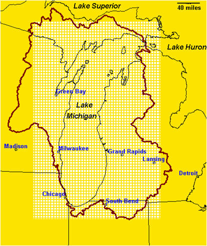
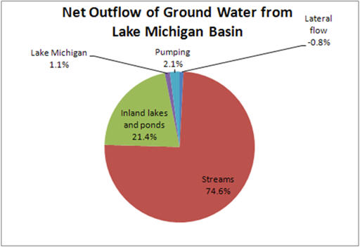
StatusGround-water availability assessment requires an understanding of the response of the ground-water system to changes in either recharge to the system, surface-water levels, or imposed pumping on the system. Ground-water-flow models typically are used to quantify these changes (for example, see Chapter 7 and Box L from Ground-Water Resources of the Middle Rio Grande Basin, USGS Circular 1222.) The ground-water-flow model for the contributing area to Lake Michigan has been developed and is currently being calibrated to observed water levels and flows in the system. The model is meant to serve as a template for other studies across the U.S. by producing indicators of water availability. It is meant to support Annex 2001 decision makers (more information regarding the Great Lakes Charter Annex of 2001) and other organizations dedicated to protecting and managing the waters of the Great Lakes Basin. The model will serve to develop and apply innovative methodologies for assessing the ground-water resource and its connection to surface water. The model simulates regional ground-water flow from 1864 through 2005. Current testing includes the use of soil-water-balance techniques to estimate recharge to the model through time and the use of SEAWAT to explore the impact of saline water within the Michigan Basin on ground-water availability.
|
![]() U.S. Department of the Interior |
U.S. Geological Survey
U.S. Department of the Interior |
U.S. Geological Survey
URL: http://mi.water.usgs.gov/projects/GreatLakesWaterAvailability/ground.html
Page Contact Information: Webmaster
Page Last Modified: Tuesday, 03-Jan-2017 11:07:35 EST