
Water Resources of Michigan
Contents of Contaminant Distribution in Sediments and Ground Water on and near Grassy Island
FWS Administrative Report
Lansing, Michigan 1999
By: M. J. Sweat
| U.S. Geological Survey Administrative Completion Report for WRD Reimbursable Agreement No. 8-4426-06000 of USFWS Parent Project No. 14-48-0003-97-905, DCN#1448-30181-97-N520 |
|
 |
|
| Prepared in cooperation with the U.S. Fish and Wildlife Service | |
| By Michael J. Sweat U.S. Geological Survey Water Resources Division 6520 Mercantile Way, Suite 5 Lansing, MI 48911-5991 |
|
| (Determination of chemical concentrations of selected metals
and inorganic and organic compounds at selected sites in the sediments and ground water on and near Grassy Island, Wyandotte National Wildlife Refuge, Detroit River, Wyandotte, Michigan) |
|
| Administrative Completion Report for WRD Reimbursable Agreement
No. 8-4426-06000 of USFWS Parent Project No. 14-48-0003-97-905, DCN#1448-30181-97-N520 |
|
Accessible Web(HTML) version is available at:
http://mi.water.usgs.gov/pubs/MISC/FWSAR99/FWSAR99LW.php
Contents
Illustrations
Figure
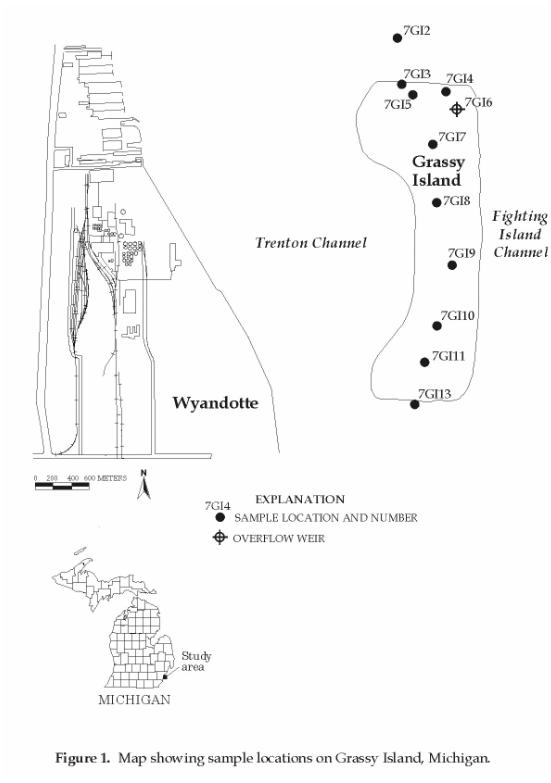
1. Map showing sample locations on Grassy Island, Michigan.
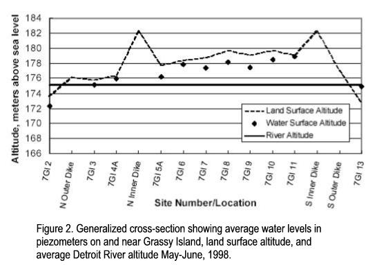
Figure 2. Generalized cross-section
showing average water levels in piezometers and near Grassy Island, land surface
altitude, and average Detroit River altitude May-June, 1998.
Tables of Data
Table 1. Trace
metals, semivolatile and volatile organic compounds, and pesticides for which
laboratory analyses were made in samples from Grassy Island.
Table 2. Sample
site name, location, and types of samples collected
Table 3. Lithologic
description of bore holes and depths at which samples were collected
Table 4. Results
of analyses for metals in sediments, Grassy Island.
Table 5. Results
of analyses for semivolatile organic compounds in sediments, Grassy Island.
Table 6. Results
of analyses for volatile organic compounds in sediments, Grassy Island.
Table 7. Results
of analyses for pesticides and aroclors (PCBs) in sediments, Grassy Island.
Table 8. Results
of analyses for metals in water, Grassy Island.
Table 9. Results
of analyses for semivolatile organic compounds in water, Grassy Island.
Table 10.
Results of analyses for volatile organic compounds in water, Grassy Island.
Table 11.
Results of analyses for pesticides and aroclors (PCBs) in water, Grassy Island.
| Conversion Factors, Abbreviated Water Quality Units, and Vertical Datum | ||
|---|---|---|
| Multiply | By | To Obtain |
| Length | ||
|
centimeter (cm)
|
.3937
|
inch
|
|
meter (m)
|
3.281
|
foot
|
| Area | ||
|
hectare (ha)
|
2.471
|
acre
|
| Flow (volume per unit time) | ||
|
cubic meter per second (m3/s)
|
35.31
|
cubic foot per second |
|
centimeter per second (cm/s)
|
105
|
gallons per day per foot squared (gal/day/ft2) |
| Temperature | ||
| Degree Celsius (°C) may be converted to degree Fahrenheit (°F) by use of the following equation: | ||
|
°F = (1.8 x °C) + 32
|
||
Abbreviated water-quality units
Chemical concentrations are given in metric units. Chemical concentration is given in milligrams per liter (mg/L), micrograms per liter (µg/L), and milligrams per kilogram (mg/kg). Milligrams per liter is a unit expressing the concentration of chemical constituents in solution as a weight (milligrams) of solute per unit volume (liter) of water. Likewise, micrograms per liter is a unit expressing the concentration of chemical constituents in solution as a weight (micrograms) of solute per unit volume (liter) of water. One thousand micrograms per liter is equivalent to one milligram per liter. For concentrations less than 7,000 mg/L, the numerical value is the same as for concentrations in parts per million. Milligrams per kilogram is a unit expressing the concentration of chemical constituents as dry weight (milligrams) of analyte per unit weight (kilograms) of dry sediment.
Vertical Datum
In this report, "sea level" refers to the National Geodetic Vertical Datum of 1929 (NGVD of 1929)-a geodetic datum derived from a general adjustment of the first-order level nets of the United States and Canada, formerly called Sea Level Datum of 1929.
|
Any use of trade, product, or firm names in this publication is for descriptive purposes only and does not imply endorsement by the U.S. Government. |