
Water Resources of Michigan
Contaminant Distribution in Sediments and Ground Water on and near Grassy Island
FWS Administrative Report
Lansing, Michigan 1999
By: M. J. Sweat
Table of Contents including Illustrations, Tables
of Data, Conversion Factors, Abbreviated Waer Quality Units, and Vertical Datum.
http://mi.water.usgs.gov/pubs/MISC/FWSAR99/FWSAR99TOC.php
I n April 1997, samples of soil were collected at 10 sites, distributed in a grid over Grassy Island for analysis of pesticides, polychlorinated biphenyls, polycyclic aromatic hydrocarbons, and heavy metals. The objective of the project was to characterize the chemical composition and distribution of contaminants in sediments at various depths and locations on the Island, and to investigate the potential for contaminant transport in ground water. Sediment samples were collected at 2 offshore sites and 8 onshore sites; water samples were collected at 1 offshore and 4 on- shore sites. Water levels were measured at all sites. A total of 30 samples were collected for analysis.
A nalyses of sediment samples were made for 28 pesticides, of which 25 were detected; analyses of sediment samples were made for 64 semivolatile organic compounds, of which 24 were detected; and analyses of sediment samples were made for 33 volatile organic compounds, of which 9 were detected. Analyses of sediment samples were made for 23 metals, of which 9 were detected. Analyses of water samples were made for 28 pesticides, of which 11 were detected; analyses of water were made for 64 semivolatile organic compounds, of which 6 were detected; and analyses of water were made for 33 volatile organic compound, of which 4 were detected. Analyses of water samples were made for 23 metals, of which 16 were detected.
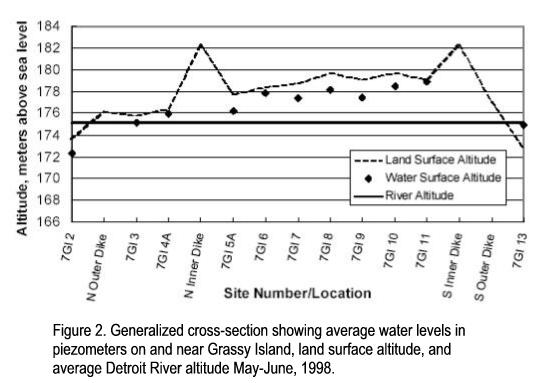
W ater levels were measured in an attempt to determine hydraulic gradients on Grassy Island. In general water levels in the river sediments were lower than those in the sediments situated between the inner and outer dikes; likewise, water levels in the sediments between the dikes were lower than were water levels in the sediments within the inner dike. Average water levels were all below land surface.
C ontaminant concentrations show little, if any, trend with depth. Native parent materials generally contain only background levels of most trace metals, although the level of some organic contaminants is elevated. Using guidelines developed by the Michigan Department of Environmental Quality, the sediments were rated with respect to their level of contamination. Sediments were found to range from not impacted by arsenic and manganese, to extremely contaminated by mercury. They were moderately impacted by chromium and iron, and severely contaminated by lead and zinc. Sediments were found to be extremely contaminated by polychlorinated biphenyls and polycyclic aromatic hydrocarbons.
C ontaminant concentrations in water exceeded United States Environmental Protection Agency (U.S. EPA) safe-drinking water guidelines for cadmium, iron, lead, and manganese. They were also exceeded for aluminum at 3 sites and barium at 1 site. Contaminant concentrations in water also exceed the guidelines for polychlorinated biphenyls.
T here are 2 surface-water impoundments on Grassy Island with the potential to transmit contaminants off the Island during periods of precipitation and overland flow. There is an overflow weir on the northeast corner of the Island. Large numbers of waterfowl were observed on these impoundments. These surface-water impoundments were not sampled.
A dditional samples of sediments and water are needed upstream, downstream, lateral to, and on the Island. Further studies of water quality are needed to identify the contaminants, if any, that are present in ponded surface water, and in water being discharged from the Island through the overflow weir. Event sampling of surface- water flow and quality in overland runoff and at the overflow weir is needed to document any connection between ponds on the north end of the Island and the overflow weir, and to document the quality and quantity of discharges to the Detroit River through the weir. Additional piezometers and wells are needed on the Island, around its perimeter, and in the Detroit River to determine the ground- water surface and the potential for movement of ground water into either the Detroit River or underlying sediments.
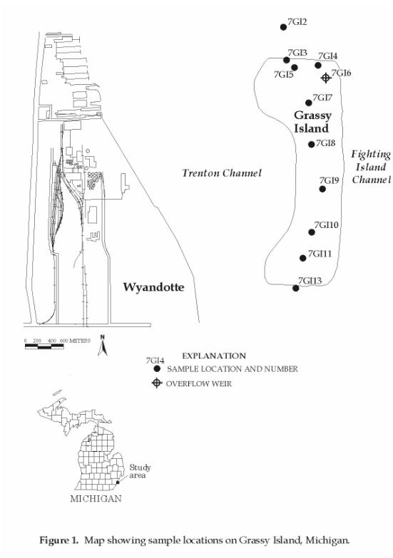
G rassy Island is part of the Wyandotte Unit of the Shiawassee National Wildlife Refuge (NWR) and administered by the Shiawassee NWR. Located in the Detroit River (fig. 1), it was selected in 1995 by the U.S. Department of the Interior as a hazardous materials management (HAZMAT) demonstration site for clean up of Federal lands. In fiscal 1997 and 1998, the U.S. Fish and Wildlife Service (USFWS) Refuge Clean?Up Fund provided funding for a study of sediment and water quality on and near Grassy Island.
T his report summarizes results of sediment and water sampling conducted by the U.S. Geological Survey (USGS) on and near Grassy Island in May and June 1997. Sediment and water samples were collected for the analysis of selected physical and chemical parameters in an attempt to determine (1) the distribution of contaminants in both sediments and ground water, (2) whether contaminants were being transported off of the Island into surrounding sediments and waters, and (3) the potential for exposure of fish and wildlife to contaminants contained on-site. Results of laboratory analyses are presented in tables at the end of the report.
S ediment samples were collected from holes dug with a hand auger using a 14 cm-diameter (5.5 in) bucket. Holes were dug until water was observed in the hole. All materials removed from the hole above the water level were then placed into a stainless steel bowl that had been washed with deionized water (DIW), rinsed with hexane, triple rinsed with organic solvent free water and allowed to air dry. The sample was homogenized, using a stainless steel spoon that had been cleaned in the same manner as the core barrel and the bowl, and then split into sample jars. The jars were then sealed, labeled, and placed into a cooler with ice to chill and maintain them at approximately 4 °C (39 °F).
T he hole was then continued below the water level until the sidewalls were no longer competent. At this point, a 13.3 cm (5.24 in) outside-diameter polyvinyl chloride (PVC) casing was inserted into the hole and pushed until resistance stopped down-hole progress. A 6.4-cm diameter (2.52 in), 61 cm (24 in) long split-spoon core barrel was then inserted into the PVC casing and coring continued until the core barrel was full. Each time the core barrel was full, the casing was driven down past the end of the core barrel and the core barrel was then extracted from the hole. In this way, slumping of the hole was prevented, and the material in the core barrel was representative of the depth through which it was driven.
A t approximately 2.5-3 m (8-10 ft) below ground-surface, a second sample was collected. Prior to and after collecting the sample, the core barrel was disassembled and cleaned with DIW, rinsed with hexane, triple rinsed with organic solvent free water, and allowed to air dry. When the core-barrel components were dry, the core barrel was reassembled and inserted into the casing to obtain a sample. The core barrel was driven into the sediment until full and then extracted from the hole. Upon extraction, the barrel was disassembled and the contents emptied into a stainless steel bowl, processed, and sampled as described previously.
S ediment samples were also collected at approximately 4.3-4.9 m (14-16 ft) depth, and in some holes at approximately 5.8-6.4 m (19-21 ft) depth. This last depth was typically in a material that by appearance and texture was identified as parent material, or sediment that was present prior to deposition of fill materials on Grassy Island.
U pon completion of sediment sampling, a short riser, if needed, was added to each PVC casing and a cap was installed to prevent foreign material from entering the well. A small annulus was created around the casing at ground surface, and bentonite-clay well seal was placed in the annulus and built up on the ground surface around the casing to prevent the infiltration of water around the casing.
S amples of river-bottom sediments were collected both upstream and downstream of the Island by use of a clay auger. The auger was turned into the bottom of the river to 1.5 times the length of the auger bucket (about 60 cm) and extracted. The river-bottom sediments were dense enough that little, if any, loss was experienced during transport through the water column. When on the boat, river-bottom sediment was composited, processed, and sampled as described above.
P iezometers (see for example Freeze and Cherry, 1979, p. 23) were installed in the river both upstream and downstream of the Island by use of stainless steel drive points. Drive points were attached to 1 m (3.3 ft) lengths of number 10 slot stainless steel well screen, which were in turn attached to 3 m (10 ft) lengths of stainless steel pipe. Drive points, screens, and pipe were then driven into the river-bottom sediments with a drive shoe until refusal. At all times the top of the casing for each piezometer was above the level of the river. All threaded joints were sealed with Teflon® tape and turned tight with chain wrenches. Casings were left about 1 m (3.3 ft) above the water surface and capped with stainless steel, threaded caps. After installation of each piezometer, all water was pumped from the piezometer so that subsequent water observed in the piezometer would be from the river-bottom sediments, and not the river. This was confirmed by observation of water levels in both the piezometer and the river, and by observing the recovery rates of water levels in the piezometers after pumping water out.
A t 4 of the onshore sites, water samples were collected from the well at a later date. Water samples were collected by placing a length of Teflon lined tubing into the casing to below the water surface. This tubing was then connected to a peristaltic pump, which lifted water from the well. Water from the well was discharged to the ground about 10 m (33 ft) from the casing. All tubing was precleaned by pumping a solution of 5 percent nitric acid into the tubing and allowing the acid solution to stand in the tubing for 1 hour. The tubing was then triple rinsed with DIW, washed with one tubing volume of methanol, triple rinsed with DIW, and allowed to dry.
T he peristaltic pump was run long enough to discharge the equivalent of 3 well volumes of water before samples were collected. At one site the well did not recharge fast enough to allow this purging to take place, and all water was pumped from the well. This well was capped and allowed to recover overnight, and then pumped again. It was then allowed to recover overnight again, and pumped a third time. After allowing recovery overnight a third time, the well was pumped and the water collected into appropriate sample containers for laboratory analysis. Each container was capped and placed in a cooler with ice to maintain sample temperature at approximately 4 °C (39 °F). In this manner enough water was collected to complete all required analyses.
A ll samples were labeled in the field as they were collected, and stored under controlled conditions at a stable temperature (4 °C (39 °F)). At the end of each week of fieldwork, samples were packed with ice in an insulated cooler and shipped via overnight courier to the contract laboratory at Texas A&M University (TAMU). This laboratory is under contract to USFWS and reports to the Patuxent Analytical Control Facility (PACF) Contract Laboratory Program (CLP). A laboratory quality assurance plan is on file at the East Lansing Field Office (ELFO) of USFWS for this laboratory. All analytical results from this laboratory were reported to PACF and subsequently to ELFO. After review by ELFO personnel the results were transmitted to the USGS, Water Resources Division (WRD) for analysis and interpretation.
T he number of sediment samples collected at each site varied from 1 to 4, depending on the location of the site. Only 1 sample was collected from each offshore site; a minimum of 3 samples were collected at each onshore site, with either parent material samples or split samples collected at 4 of the sites. Lithologic descriptions of the sediment samples and their depths below land surface are presented in table 3.
L aboratory analyses were made on each sediment sample for metals, semivolatile and volatile organics, and pesticides. The complete list of analytes is given in table 1. Results of these analyses are given in tables 4 through 7. Only those analytes that were detected above the method- reporting limit are listed in tables 4 through 7. All other analytes listed in table 1, but not in tables 4 through 7 were either not present, or were present in quantities above the method detection limit but below the method-reporting limit.
O f 23 metals for which analyses were made, 9 were detected in sediment samples (table 4). The most commonly detected metals were aluminum, iron, lead, manganese and mercury. Arsenic, chromium, and zinc were also frequently detected. Analyses were made for 64 semivolatile organic compounds, of which 23 were detected (table 5). Analyses were made for 33 volatile organic compounds, of which 9 were detected (table 6). Of these 9 volatile organic compounds detected, 5 of them were detected in only 1 sample (1 compound detected) or 2 samples (4 compounds detected). Analyses were made for 28 pesticides, of which 25 were detected (table 7); however, 13 of the pesticides detected were in 4 or fewer samples.
A water sample was collected at site 7GI 13, but not at site 7GI 2. An attempt was made to collect a sample at site 7GI 2 but the piezometer was not capable of producing sufficient water for sampling. At site 7GI 13 a water sample was collected from the piezometer, and from the river near the piezometer. This was done for comparative purposes in an attempt to determine if the water in the piezometer was truly from the parent materials, to determine if there was any leakage in the piezometer joints, and to determine if measured differences between river water and ground water were statistically valid.
A dditional water samples were collected from sites 7GI 4, 7GI 5, 7GI 6, and 7GI 11. The sample from 7GI 11 was split into 2 samples for comparative purposes. Samples at each of these sites were collected as previously described from the PVC casing that was installed in each borehole.
L aboratory analyses were made on each water sample for metals, semivolatile and volatile organics, and pesticides. The complete list of analytes is given in table 1. Results of water analyses are given in tables 8 through 11. Only those analytes that were present above the method- reporting limit are shown in tables 8 through 11; all other analytes listed in table 1 but not in tables 8 through 11 either were not present or were present in quantities below the method-reporting limit.
O f 23 metals for which analyses were conducted, 16 were detected in water samples (table 8). The most commonly detected metals were aluminum, calcium, iron, magnesium, manganese, sodium and zinc. Analyses were made for 64 semivolatile organic compounds, of which 6 were detected (table 9). Of these 6 semivolatile organic compounds detected, 4 of them were detected in only 1 or 2 samples. Analyses were made for 33 volatile organic compounds, of which 4 were detected (table 10). Analyses were made for 27 pesticides, of which 11 were detected (table 11); however, 7 of the pesticides detected were in 2 or fewer samples.
| Well Number | Land Surface Altitude | Average Water Level Altitude |
|---|---|---|
| GI12 | 173.65 | 172.30 |
| 7GI3 | 175.81 | 175.98 |
| 7GI4A | 176.46 | 175.98 |
| 7GI5A | 177.78 | 176.26 |
| 7GI6 | 178.43 | 177.92 |
| 7GI7 | 178.76 | 177.38 |
| 7GI8 | 179.74 | 178.14 |
| 7GI9 | 179.09 | 177.49 |
| 7GI10 | 179.74 | 178.50 |
| 7GI11 | 179.09 | 178.92 |
| 7GI13 | 172.73 | 174.95 |
I n general, water levels in the river sediments were lower than those in the sediments situated between the dikes. Likewise, water levels in the sediments between the dikes were lower than were water levels in the sediments within the inner dike. At three locations within the inner dike, one or more water levels were measured that were above the land surface. Average water levels were all below land surface. All of these water level measurements indicate that there is a hydraulic gradient from within the inner dike toward the area within the outer dike, and consequently to the Detroit River.
DISTRIBUTION OF CONTAMINANTS
I
n general, recent studies of sediments on and near Grassy Island have found them to be grossly contaminated (Ostaszewski, 1997; Manny, 1999b) with metals, semivolatile and volatile organic compounds, pesticides, and aroclors (PCBs). Historical studies of the Island and surrounding waters and sediments have produced mixed findings (Manny, 1999a). Beyer and Stafford (1993) found that earthworms and soils on Grassy Island contained elevated concentrations of cadmium, copper, and lead, with levels in earthworms several times those in the surrounding soils. Best and others (1992) found elevated concentrations of some heavy metals and aroclors (PCBs) in pond sediments. Concentrations of chlordane, DDE, DDD, phenanthrene, and benzo (g,h,i)perylene exceeded criteria established to protect ground water, and aroclor (PCB) and chlordane levels exceeded criteria established to
protect surface water. Best and others (1992) and Eisler (1988) found elevated levels of aroclors (PCBs), DDT, and mercury in tissue and organ samples from waterfowl taken on the Island.
Figure 1. Map showing sample locations on Grassy Island, Michigan.
O ther studies, however, have had contradictory findings, and lead to mixed conclusions about the level of contamination in surrounding sediments and waters. Thornley and Hamdy (1984) found only mercury in sediments immediately upstream and downstream of Grassy Island. A study for the U.S. Army Corps of Engineers (Environmental Research Group, 1983) found no contamination of sediments immediately next to the Island and in other nearshore sediments in the shipping channel east of the Island; however, U.S. EPA studies in 1987 and again in 1991 (U.S. Environmental Protection Agency, 1987, 1991) contradict these findings. These U.S. EPA studies found that there was "some impact to sediments" from oil and grease, heavy metals, PAHs, and PCBs. However, a later study by Besser and others (1996) of sediments from the same area concurs with the earlier findings of Thornley and Hamdy (1984), and concludes that "sediments of the Fighting Island reference site were not toxic and included pollution-intolerant taxa." Finally, a study by Environment Canada (1997) found that concentrations of DDE and PCBs in Herring Gull eggs have "decreased significantly, to less than 15 percent of their 1971 values," indicating that levels of organochlorine contaminants have decreased in Detroit River fish consumed by Herring Gulls.
L ewis (1991) used geophysical methods to survey the southwest corner of the Island and detected possible buried drums at a depth of 6-9 m (20-30 ft). This finding is of interest as a possible source of organic contaminants. No further work was completed to confirm or refute these findings.
N ative parent materials generally contain only background levels of most trace metals, and do not appear to be impacted by overlying materials. Although arsenic was reported in the parent material samples, it was detected below the method-reporting limit of 10 µg/kg, and was not present in 2 of the 5 native parent material samples. The median arsenic level present in native parent materials was 1.65 µg/kg, with a mean level of 1.21 µg/kg. Lead was reported present in 3 of 5 native parent material samples, with a median level of 2.09 µg/kg, which is below the method reporting limit of 3 µg/kg. The mean level, 2.92 µg/kg, is also below the method- reporting limit. Mercury was present in all but one of the sediment samples from the Island, but was not present in any of the native parent material samples.
A t site 5, 11 of 23 detected semivolatile organic compounds were detected in the native parent sample material, and at site 11, 6 of 23 detected semivolatile organic compounds were detected in the native parent sample material. At site 5 the concentrations range from less than twice the reporting limit for 4-chlorophenylphenylether (609 µg/kg detected, 330 µg/kg reporting limit) to over 7 times the reporting limit for fluoranthene (2471 µg/kg detected, 330 µg/kg method reporting limit). At site 11, all values are less than twice the method-reporting limit.
T he volatile organic compound methylene chloride was detected in 3 of 5 native parent material samples. In general, methylene chloride was either present in every sample from a site (sites 2,4,6,7,8, and 13) or not present in any samples from a site (sites 5 and 9). It was present in one of two split samples from site 10, and all but the native parent material samples at site 11. Only 2 other substances were present in any native parent material samples. They were 4-methyl-2-pentanone, which was present in native parent material from site 11 at 3 times the method-reporting limit, and 2-hexanone, which was present in native parent material from site 4 at 6 times the method-reporting limit. In general, volatile organic compounds were present in few of the samples, and generally at depth when they were detected.
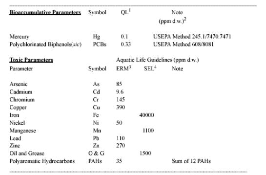
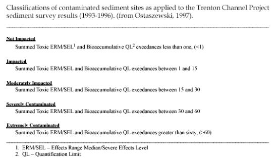
F rom 1993-96, Ostaszewski (1997) studied sediment chemistry in the Trenton Channel, which lies along the west side of Grassy Island (figure 1). One result of this study was a classification of contaminated sediments. Ostaszewski's table A (1997), lists parameters and guideline levels used to evaluate Trenton Channel project sediment results. These guidelines have been applied to sediments collected on and near Grassy Island for this project. The quantification limits (QL) and aquatic life guidelines given by Ostaszewski (1997) are in ppm, as are the results of the sediment analyses for this study. The numbers are therefore directly comparable.
Parameters and guideline levels used to evaluate
Trenton Channel Project sediment results. (from Ostaszewski, 1997).
Accessible version
E xceedances were calculated for all analytes, following the method of Ostaszewski (1997), for 7 metals, polycyclic aromatic hydrocarbons (PAHs), and polychlorinated biphenyls (PCBs). Exceedances are defined by Ostaszewski (1997) as the sum of detections for all analytes that exceed the quantification limit (QL), the effects range median guidelines (ERM - Long and Morgan, 1990), or the severe effect levels (SEL - Persaud and others, 1993), divided by the QL, ERM, or SEL. Ostaszewski (1997) then divided the results into 5 categories, also shown below.
S ediments on Grassy Island were found to range from not impacted by arsenic and manganese, to extremely contaminated by mercury. They were moderately impacted by chromium and iron, and severely contaminated by lead and zinc. Although arsenic was detected in 16 of 30 samples for which it was analyzed, it was not present at levels equal to or greater than the ERM, and therefor the sediments, by Ostaszewski's criteria, are not impacted. Likewise for manganese, which was detected in 26 of 30 samples for which it was analyzed. Ostaszewski did not establish parameters and guideline levels for evaluating contamination by aluminum or selenium.
P AHs, the sum of 16 organic contaminants for which analyses were made, were found at levels that cause the sediments to be classified as extremely contaminated. PCBs, the sum of 6 aroclors, were present at levels that cause the sediments to be classified as extremely contaminated. No pesticides or aroclors (PCBs) were detected in any samples of native parent material. In general, pesticides and aroclors were noticeably absent most samples except for samples taken in the saturated zone at sites 10 and 11. Both of these sites contained numerous pesticides and aroclors, generally at the deepest and second from deepest samples at site 10, and at the first saturated sample at site 11.
Classifications of contaminated sediment sites as applied to the Trenton Channel Project sediment survey results (1993-1996). (from Ostaszewski, 1997).
Accessible version
Contaminants in Water
A
luminum, calcium, chromium, copper, iron, magnesium, manganese, sodium, and zinc were the most commonly detected metals in water. In water, concentrations of trace metals followed those of the sediments from which the water was extracted. Aluminum, calcium, chromium, copper, iron, magnesium, manganese, potassium, sodium, and zinc were the most frequently reported trace metals in water samples. Calcium, iron, magnesium, sodium, and zinc were the only metals reported in the one sample of river water. Arsenic and barium were present only in the split samples from site 11; mercury was reported in water from site 5, although at only slightly more than the method-reporting limit (0.23634 µg/L reported, 0.2 µg/L method-reporting limit).
A lthough the classification system developed by Ostaszewski (1997) was for sediments, it was applied to the results obtained for chemical analyses of water for this study. In addition, results of analyses were compared to U.S. EPA drinking water standards (USEPA, 1996). Using the classification of Ostaszewski, all water samples would be classified as not impacted. Using data from table 8, comparison to U.S. EPA drinking water standards indicates that cadmium, iron, lead, and manganese exceed these standards at 1, 5, 3 and 4 sites respectively. In addition, drinking water standards are established for aluminum and barium; aluminum concentrations in water exceed these standards at 3 sites and barium concentrations exceed these standards at 1 site. The Michigan Department of Public Health has established an objectionable level for sodium of 250 mg/L. Comparing the objectionable level to data from table 8 indicates that sodium concentrations in water do not exceed this level.
P henol was the only semivolatile organic compound reported in water not originating on the Island. In general, semivolatile organic compounds were reported at or slightly above the method-reporting limit for those compounds that were detected. Bis(2-Ethylhexyl)phthalate was the most commonly detected semivolatile organic compound, present in water samples from all but sites 6 and 13.
A s with sediment sample results, methylene chloride was the most commonly detected volatile organic compound, reported in all water samples except that from the Detroit River. Acetone was the second most commonly detected volatile organic compound in water. Acetone was reported at such high concentrations in sample 7GI 13Wp that a rerun was requested from the lab. As of this writing, results of this rerun have not been received. Comparing PAH concentrations to the ERM and Ostaszewski's contaminant classification indicates that waters are not impacted with respect to PAHs. There is no USEPA drinking water primary or secondary maximum contaminant level established for PAHs.
N o pesticides or aroclors (PCBs) were detected in the water sample from the Detroit River. Only aroclors were detected in the water sample from the river piezometer, and then only at the method-reporting limit. Site 7GI 5 was the only site with notable aroclor concentrations reported. At all other sites, aroclor concentrations, when reported, were at the method- reporting limit. Comparing aroclor concentrations to the QL and Ostaszewski's contaminant classification indicates that the waters are not impacted; however, the sum of aroclors does exceed the USEPA drinking water standards for PCBs. The pesticide gamma chlordane was reported in water samples from 3 sites, again at the method-reporting limit.
O f greater concern are surface impoundments of water on the Island and their potential to transmit contaminants off the Island during periods of precipitation and overland flow. Currently there is an overflow weir and discharge chamber on the northeast corner of the Island. This weir and discharge chamber is connected to a pipe that discharges surface flows into the Detroit River at an indeterminate point. Flow of water into this system is apparently by ground water seepage, and during periods of precipitation, possibly by overland flow. A water quality sample was collected from the weir but was not analyzed because of budget limitations.
T here is a small surface impoundment of water that flows into the weir; however, at the northwest end of the Island and the southern end of the Island there are large areas (greater than 1 h (3 acres)) of standing water. This water may discharge through the weir, although it is more likely that these ponded waters increase in volume by precipitation and overland runoff, and lose content by evaporation and transpiration, not discharge through the weir. No obvious areas of seepage through the containment dikes were observed, nor were there any obvious areas of breaching or failure.
L arge numbers of waterfowl were observed on these ponds. It is likely that some of these waterfowl use the Island as a nesting area and raise their broods on the Island (Douglas Spencer, USFWS, oral commun., 1997; Bruce Manny, written commun., 1997, 1998; Dave Best, USFWS, written commun., 1998). Other migratory birds were also observed on the Island, along with deer and groundhogs. Numerous groundhog burrows were noted at locations along the upper dike, generally near the top of the dike and at a level well above any ponded water.
I n general, the data collected for this study indicate that contaminants on Grassy Island are contained in the sediments on the Island and are not moving from the Island to the surrounding sediments or waters at detectable levels. Native parent materials are generally identified as glaciolacustrine clays, which have low hydraulic conductivities (10-7-10-10 cm/s (10-2- 10-5 gal/day/ft2); Freeze and Cherry, 1979, p. #29) and thus are poor conduits for the transmission of contaminants. Most contaminants reported in the sediments and water on the Island are found neither in the parent materials, nor in the water of the Detroit River immediately downstream of the Island. Because of the low hydraulic conductivity of the underlying sediments on the Island, it is unlikely that surface water is able to infiltrate into the ground-water system, and therefore is also unlikely that the ground water is moving laterally or vertically through the Island in significant quantities. It is more likely that the precipitation that falls on the Island is transported into and through the more permeable surface materials, from which it is directly evaporated into the atmosphere or incorporated into vegetation, from which it evapotranspires into the atmosphere.
I n order to make statements about the connection between Island soils, the nature of contaminated dredge spoils placed on the Island, and the underlying substrate, additional geophysical investigations and additional drilling of cores are needed. To fully compare the quality of sediments and water on the Island to those in the surrounding riverine environment, additional samples are needed upstream from, downstream from, and lateral to the Island. Studies of contaminants in the vegetation growing on the Island should be made to determine what role, if any, vegetation plays in the movement of contaminants from the sediments to ground water, surface water, and wildlife. It is likely that phragmites, laurel, cottonwood, willow and other plants are vectors for chemical exchange between sediments, ground water, surface water, the atmosphere, and wildlife. Plants could also function as a mechanism for movement of semivolatile and volatile contaminants in the root zone. The contaminant content of soil and sediment-dwelling invertebrates should also be sampled.
Besser, J.M., Giesy, J.P., Kubitz, D.A., Verbrugge, T.G.Coon, and Braselton, W.E., 1996, Assessment of sediment quality in dredged and undredged areas of the Trenton Channel of the Detroit River, Michigan USA, using the sediment quality triad: Journal of Great Lakes Research, V 22, pp. 683-696.
Best, D.A., Kubiak, T.J., and Boellstorff, D.E., 1992, Survey of contaminants in sediment and biota within the Grassy Island confined disposal facility, Wyandotte National Wildlife Refuge: U.S. Fish and Wildlife Service, Division of Ecological Services, East Lansing Field Office, East Lansing, MI, Contaminants Program, 27 p.
Beyer, W.N., and Stafford, C., 1993, Survey and evaluation of contaminants in earthworms and in soils derived from dredged material at confined disposal facilities in the Great Lakes Region: Environmental Monitoring and Assessment, vol. 24, pp. 155-165.
Eisler, R., 1988, Lead hazards to fish, wildlife, and invertebrates: A synoptic review: U.S. Fish and Wildlife Service, Biological Report 85(1.14), 134 p.
Environment Canada, 1997, Contaminants in Herring Gull eggs from the Great Lakes: 25 years of monitoring levels and effects: Great Lakes Fact Sheet No. En 40- 222/6-1997E, 12 p.
Environmental Research Group, 1983, Analytical report to the Army Corps of Engineers on water quality, elutriate, and sediment samples from the Detroit River on April 27 and 29, 1983 and the St. Clair River on May 3 and 4, 1983: ERG project No. 9618, 90 p.
Freeze, R.A., and Cherry, J.A., 1979, Groundwater: Englewood Cliffs, New Jersey, Prentice-Hall, 604 p.
Lewis, R.D., 1991, Geophysical investigation of the Grassy Island confined disposal area, Detroit, Michigan: Department of the Army, Corps of Engineers, Waterways Experiment Station, Vicksburg, MI, Technical Report GL-91-15, 16 p.
Long, E.R. and Morgan, L.G., 1990, The potential for biological effects of sediment- sorbed contaminants tested in the National Status and Trends Program: National Oceanic and Atmospheric Administration Technical Memorandum NOS OMA 62, National Oceanic and Atmospheric Administration, Seattle, WA, 174 p.
Manny, B.A., 1999, Contamination distribution and movement at Grassy Island (Background and history of contaminants in sediments on and near Grassy Island in the Wyandotte National Wildlife in the Detroit River, Michigan), Completion Report for NBS Reimbursable Agreement No: 84080-1941-MH25 (14-06-0907) of USFWS Parent Project No. 14-48-0003-96- 1050, 27 p.
-----, 1999, Contamination of surface soils and wild celery tubers at Grassy Island in the Wyandotte National Wildlife Refuge in the Detroit River, Michigan, Completion Report for NBS Reimburse able Agreement No: 84080-1941-MH25 (14-06-0907) of USFWS Parent Project No. 14-48-0003- 96-1050, 13 p.
Ostaszewski, Arthur, 1997, Results of the Trenton Channel Project Sediment Surveys, 1993-1996: Michigan Department of Environmental Quality, Surface Water Quality Division, U.S. EPA-GLNPO Grant # GL-995960-02-0, Completion Report MI/ DEQ/SWQ-97/084. 20 p., 3 tables, 31 figures, 2 appendices.
Persaud, D., Jaagumagi, R., and Hayton, A., 1993, Guidelines for the protection and management of aquatic sediment quality in Ontario: Water Resources Branch, Ontario Ministry of the Environment, Toronto, Ontario, Canada.
Thornley, S. and Hamdy, Y., 1984, An assessment of the bottom fauna and sediments of the Detroit River: Ontario Ministry of the Environment, Toronto, Ontario, 48 p.
U.S. Environmental Protection Agency, 1974, Water Pollution Investigation, Detroit and St. Clair Rivers: EPA-905/9-74- 013, 348 p.
-----, 1987, 1982 Detroit, Michigan Area Sediment Survey: USEPA, Great Lakes National Program Office, Chicago, IL, EPA-905/4-87-003, 116 p.
-----, 1996, Drinking water regulations and health advisories: EPA 822-B-96-002.
Average water levels and land surface
altitude at piezometer sites on Grassy
Island. [Altitude in meters above sea level]
Citation: