
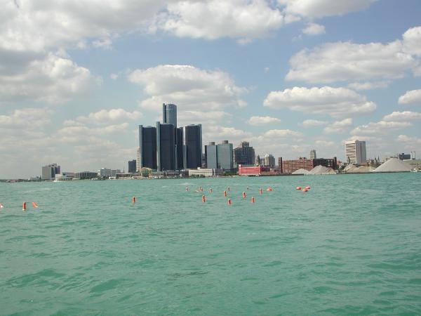
![]() Drifting Buoy Deployments on St. Clair River from October 3- 5, 2000
Drifting Buoy Deployments on St. Clair River from October 3- 5, 2000
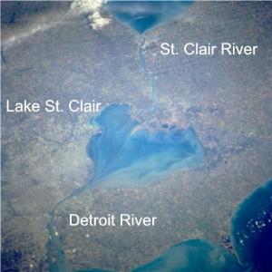
![]() Flow Modeling Study of the St. Clair - Detroit River Waterway
Flow Modeling Study of the St. Clair - Detroit River Waterway
|
||||
| Michigan Water Science Center |
|
Project Chief Dave Holtschlag Statewide Water Resources Monitoring Protection of Drinking Water Sources Effects of Land Use on Water Quality
Restoring Natural Flow Regimes Research and Technical Assistance at Contaminated Sites Table of Contents |
 Source Water Assessment and Protection (SWAP)
The Michigan Department of Environmental Quality (MDEQ) is completing a Source Water Assessment Program as required by the 1996 reauthorization of the federal Safe Drinking Water Act (SDWA). The 1996 amendments to the SDWA require states to:
Water for about half of the residents in Michigan comes from the 80-mile long waterway formed by St. Clair River, Lake St. Clair, and Detroit River between southeastern Michigan and southwestern Ontario, Canada. This study will develop a sophisticated computer model to identify likely sources of water to public supply intakes and provide a basis for planning emergency responses to contaminant spills along the waterway. The flow model is being developed by USGS in partnership with MDEQ, City of Detroit, USACE, and NOAA. Information is also coordinated with Environment Canada. The flow model will provide two-dimensional (depth-averaged) flow information in real time, and will provide a basis for future water-quality studies to describe the transport of sediments and the fate of conservative and non-conservative constituents.
Portable Document Format (PDF) of report is at:
If you do not have Adobe® Acrobat® Reader, then you can download it for free at:
Reference: Cooperators: MDEQ Source Water Assessment Program Detroit Water and Sewerage Department Related Links Acknowledgement: |

![]() U.S. Department of the Interior |
U.S. Geological Survey
U.S. Department of the Interior |
U.S. Geological Survey
URL:
Page Contact Information: Webmaster(gs-w-milns_webmaster@usgs.gov)
Page Last Modified: Last modified: June 23 2006 11:00:49.