
FIGURES
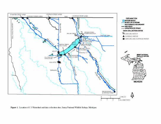
1. Map showing location of C-3 watershed
and data collection points
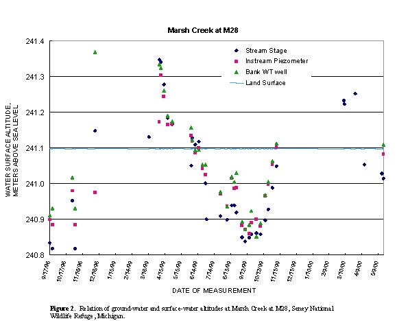
2. Graph showing the relation of ground water
and surface-water altitudes at
Marsh Creek at M28
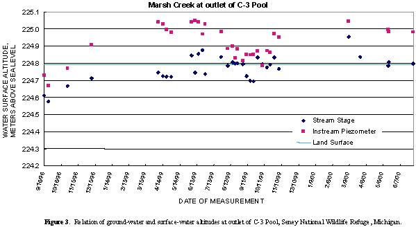
3. Graph showing the relation of ground-water
and surface-water altitudes at
Marsh Creek at outlet of C-3 Pool
TABLES
1. Measured discharge and estimated daily
discharge of selected streams near Seney
National Wildlife Refuge, Michigan, 1998-2000
2. Altitude of water in wells and piezometers
near Seney National Wildlife Refuge,
Michigan, 1998-2000
3. Altitude of water in miscellaneous wells
and piezometers above an arbitrary datum
near Seney National Wildlife Refuge, Michigan, 1998-2000
| Conversion Factors, Abbreviations, and Vertical Datum | ||
|---|---|---|
| Multiply | By | To Obtain |
| Length | ||
| centimeter (cm) | 0.3937 | inch |
| meter (m) | 3.281 | foot |
| kilometer (km) | 0.621 | mile |
| Area | ||
| hectare (ha) | 2.471 | acre |
| square kilometer (km2) | 0.3861 | square mile |
| Volume | ||
| cubic meter (m3) | 35.32 | cubic foot |
| Velocity | ||
| meters per second (m/s) | 3.281 | feet per second |
| Flow (volume per unit time) | ||
| cubic meter per second (m3/s) | 35.32 | cubic foot per second |
| cubic meter per second (m3/s) | 86,400 | cubic meter per day |
| cubic meter per day (m3/d) | 35.32 | cubic foot per day |
| Temperature | ||
| Degree Celsius (×C) may be converted to degree Fahrenheit (×F) by use of the following equation: | ||
| ×F = (1.8 x ×C) + 32 | ||
| Vertical Datum | ||
| In this report, "sea level" refers to the National Geodetic Vertical Datum of 1929 (NGVD of 1929)—a geodetic datum derived from a general adjustment of the first-order level nets of the United States and Canada, formerly called Sea Level Datum of 1929. | ||
| For additional information write to:
|
Copies of this report can be purchased from:
|