
INTRODUCTION
People choose to reside, work, and vacation in coastal areas of the Great Lakes because of the lakes' scenic beauty and their historic and cultural features. Great Lakes nearshore areas also constitute a valuable economic resource. Two million anglers added $1 billion to the region's economy in 1996. More than 300 million tons of goods were transported out of major Great Lakes ports at a value of $3 billion in 1996. A 1998 survey of Lake Erie beaches estimated contributions of $5 million per year to each local economy with a public beach. More than 70 million people yearly visit national, state and provincial parks in the Great Lakes area. Uncontrolled land development, recreational development, invasive species, climate change, water availability, and water-level changes and fluctuations lead a long list of current and potential issues in coastal and nearshore areas. To be effectively addressed, these complex issues require an interdisciplinary approach.
The U.S. Geological Survey (USGS) has regional, national, and international experience and capabilities in coastal science in the fields of geology, geography, hydrology, and biology-experience and capabilities with significant potential to address critical and complex ecosystem issues facing the Great Lakes. Through its programs, the USGS can provide interdisciplinary research and models for factors that affect Great Lakes coastal and nearshore ecosystems, along with decision support tools that can be used by land- and water-resources managers at all levels of government.
POTENTIAL CONTRIBUTIONS OF DIFFERENT SCIENCES TO AN INTERDISCIPLINARY APPROACH
USGS geologists investigate the geologic framework to understand the response of landscapes and coastal systems to changes in climate and lake levels over time. The geologic framework provides some of the major nearshore controls on modern hydrology and ecosystem dynamics. Geologic factors affect the quality and number of beaches, coastal wetlands, sand and gravel deposits, and areas suitable for development in the Great Lakes. Geologic framework studies include investigation of the structure and composition of the rock and sediment at the surface and at depth in coastal areas.
Geologic processes that produced and continue to modify the geologic framework include sediment erosion, transport, and deposition; Recent and Pleistocene lake-level changes; geochemical fluxes and transformations; and complex interactions between biota and water. USGS expertise offers local- to regional-scale synthesis, interpretation, and understanding of geologic processes.
USGS geologists conduct studies of the following:
- Coastal and offshore morphology
- Onshore, coastal, and offshore erosion and deposition
- Coastal dune dynamics and slope stability
- Lake ice dynamics
- Climate history based on ancient lake levels
- Distribution of Pleistocene and Recent sediments
- Weathering and soil development and soil/substrate geochemistry.
USGS geologists possess a modern suite of tools for studying coastal areas, including:
- Acoustic and LIDAR (Light Detection and Ranging) equipment to map the coast and offshore
- Geophysical sensors
- Coring capabilities
- Spatial-data analysis
- Digital three-dimensional geologic mapping
- Analytical techniques in the fields of geochemistry, sediment dynamics, isotope geology, and geochronology.
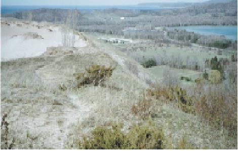
Products include geographic information systems showing geologic features that can be overlain with biologic, hydrologic, social, and cultural features. Previous coastal studies in the Great Lakes have provided data on the relation between coastal erosion and bluff/dune stability in Illinois, Michigan and Ohio; and on lake-level history. Coastal and offshore geologic maps have been compiled for Ohio, Illinois, and Michigan.
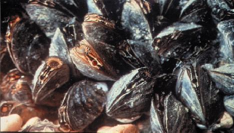
Figure 2. Coastal dunes provide the geologic foundation for critical nearshore ecosystems. (27KB)
USGS geographers and cartographers provide expertise in physical and cultural geography, cartography, and information management. Studies of processes in nearshore and coastal environments are supported and enhanced by geographic analysis and applications research, mapping-techniques development, and by production, integration, and management of spatial data.
Geographers at the USGS characterize the landscape by use of remote sensing and geographic information systems and they analyze geographic, social, and cultural trends to understand patterns of land-surface changes. They apply mapping capabilities to investigations of human health and the environment, geopositioning and photogrammetry, and naturalhazards. In addition to their interpretive activities, USGS geographers collect, process, archive, and disseminate remotely sensed data.
Spatial-data collection, production, and integration activities include development of the National Map—a seamless framework that includes elevation, hydrography, land characterization, and orthoimagery databases. These data provide a geographic foundation that can be applied to many studies of Great Lakes coastal and nearshore processes.
Information management capabilities include development and maintenance of databases of USGS products and the delivery of USGS Great Lakes data and information to the public. USGS geographers also develop and apply geographic analysis methods to identify relations among land-surface changes, environmental problems, and population trends to determine indicators of sustainable ecosystems for the Great Lakes coastal environment. A primary goal of USGS cartographic activities is to develop predictive models and data standards for use by other scientists.
USGS hydrologists analyze the hydrologic setting and quality of water in streams, lakes, wetlands and aquifers. Understanding surface-water interactions with ground water, patterns of water circulation, water quantity, and water quality is necessary to address many Great Lakes ecosystem issues. These include questions of acceptability of beaches; productivity of coastal wetlands and nearshore areas; contamination of water and sediments of rivers, harbors, wetlands, and estuaries; water quality for humans, wildlife, and ecosystem health; water availability; floods and droughts; and sustainable development.
The USGS provides daily streamflow data at more than 300 stations on tributaries to the Great Lakes. These data support planning for water use and treatment, facility design, floods and droughts, and source-water protection. In addition, they provide valuable information for waterquality studies, prediction of future trends in streamflow that may result from climatic change, and understanding the potential effects of water diversion and bulk export. The USGS uses new technology for measuring streamflow in estuary areas of Great Lakes tributaries to improve estimates of contaminant delivery. Most of the streamflow data collected by the USGS is available in near real-time format. USGS also compiles information on water use in cooperation with the states and reports on national and Great Lakes regional water use at 5-year intervals.
USGS hydrologists study the quality of ground and surface water and effects of water quality on aquatic biology. The National Water-Quality Assessment Program (NAWQA) provides water-chemistry, aquatic-biology, and ancillary data in two major drainage areas of the Great Lakes Basin: the Western Lake Michigan Drainages and the Lake Erie-Lake St. Clair Drainages. These data can be used to assess the status, trends, and factors influencing the transport and loadings of contaminants to coastal areas of the Great Lakes from rivers and ground water.
USGS hydrologists also develop new approaches for evaluating the chemical quality of water. For example, the Toxic Substances Hydrology Program has conducted a national reconnaissance of "emerging contaminants" in three categories: human and veterinary pharmaceuticals, industrial- and householdwastewater products, and steroidal hormones. Selected tributaries to the Great Lakes in Michigan, Ohio, and Wisconsin were included in this survey.
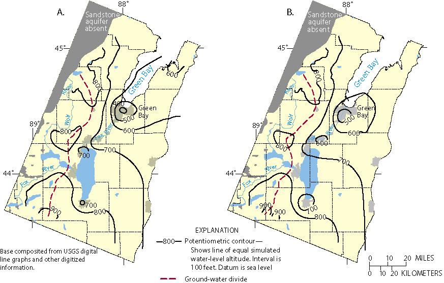
Excessive ground-water withdrawals have affected the ground-water and surface-water flow systems in some areas of the Great Lakes Basin. For example, in the Green Bay-Fox River area of Wisconsin, the sandstone aquifer is used as a water-supply source. Water levels declined as much as 300 feet and were deep enough in 1957 that the city of Green Bay began pumping water from Lake Michigan to supplement ground-water sources.
As an additional example, the Toledo, Ohio, metropolitan area obtains water from wells open to a carbonate aquifer and from quarry dewatering near Lake Erie. Pumping has lowered water levels in wells as much as 35 feet below the average level of Lake Erie. Such pumping has induced infiltration from Lake Erie into the ground-water system and intercepted water that would have discharged from the ground-water system to Lake Erie. The effects of large-scale movements of ground water on the Great Lakes nearshore environment are largely unknown.
USGS scientists conduct a wide variety of biological research in the Great Lakes Basin in wetlands and terrestrial and aquatic environments, addressing invasive species and their control, fish-stock assessment, fisheries research, and wildlife health.
USGS biological expertise includes fish, invertebrate, and plant systematics; microbial, aquatic, wetland, and coastal ecology; biochemistry, physiology, toxicology and disease; and microbial, invertebrate, fish, and largeanimal population dynamics and trophic interactions.
The USGS Great Lakes Science Center (GLSC) in Ann Arbor, Michigan, has studied the major adult fish populations in the Great Lakes for more than 30 years, providing resource managers with annual estimates of forage-fish biomass. Recent biodiversity studies of invertebrates, supported in part by The Nature Conservancy, provide interactive taxonomic keys for major invertebrate groups in the Great Lakes.
USGS biologists study ways to limit the spread or impact of invasive species. USGS has pioneered the use of various barriers to allow native fish access to wetland spawning areas while limiting invasive carp. USGS, in cooperation with the Great Lakes Fishery Commission, has decades of experience in research to decrease populations of the sea lamprey and has helped develop a highly effective Integrated Pest Management Control Program, which includes chemical treatment of spawning streams, sterile male release, and use of lowhead barrier dams during spawning runs of sea lamprey. USGS, with support from U.S. Army Corps of Engineers and U.S. Fish and Wildlife Service, has also worked on barriers to halt the spread of invasive species through man-made connections between watersheds.
The USGS has the largest fleet of research vessels on the Great Lakes. The fleet consists of five large (45-107 foot) and several small (20-25 foot) vessels stationed throughout the Great Lakes. These vessels are equipped to sample fish, aquatic invertebrates, and water quality. Laboratory facilities allow for the identification of taxa, quantification of prey abundance and diets, and analysis of water quality. USGS research divers assess biota and deploy underwater monitoring equipment.
The USGS National Wildlife Health Center (NWHC) in Madison, Wisconsin, is a biomedical laboratory dedicated to assessing wildlife disease. Specialized biological containment facilities enable USGS biologists to investigate highly infectious diseases affecting a broad spectrum of Great Lakes wildlife including amphibians, birds, and large mammals. USGS biomedical scientists monitor and assess the impact of disease on wildlife populations; define ecological relationships leading to the occurrence of disease in wildlife; provide rapid on-site investigation of wildlife disease emergencies; and provide guidance, training, and technical information and support for reducing wildlife losses when outbreaks of disease occur. USGS biologists evaluate the impact of disease on coastal wildlife population dynamics, model environmental factors influencing disease outbreaks, explore the pathogenesis of disease agents in susceptible hosts, and develop enhanced technology for disease detection and diagnosis.
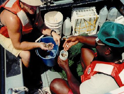
Figure 6. USGS biologists examine a catch of juvenile fish. (34KB)
EXAMPLES OF USGS INTERDISCIPLINARY NEARSHORE STUDIES IN THE GREAT LAKES AREA
INFORMATION FOR BEACH MANAGEMENT
USGS research in hydrology and biology has been instrumental in providing information to beach managers on the hydrological, chemical, and microbiological characteristics of recreational waters. In cooperation with the City of Chicago, USGS scientists undertook an intensive study of the nearshore waters, submerged and foreshore sands, gull droppings, and other possible sources of the bacteria Escherichia coli (E. coli) and Salmonella. By means of models developed in collaboration with Purdue University, the regulatory exceedances of E. coli were accurately predicted 79 percent of the time. USGS scientists used DNA-fingerprints of E. coli and Salmonella bacteria to identify their potential sources. Similar USGS studies are underway at Lake Erie public beaches in cooperation with state and local agencies.
GEOLOGIC SUBSTRATE AND FISH HABITAT
To improve modeling and prediction of fish-population changes, more information is needed concerning the earlier life stages and the lower trophic levels. USGS scientists have begun studying the relation between the distribution and abundance of larval fish and invertebrate species and the geologic substrate that forms their breeding and nursery grounds in the nearshore zone of west-central Lake Erie. This study is partially funded by the Ohio Lake Erie Protection Fund with support from the Ohio Geological Survey and other State partners. Already, USGS researchers have found a diverse assemblage of larval fishes throughout the growing season in an open, high-energy area previously considered by many to be devoid of nursery habitat for fishes.
In a second study, USGS geologists and biologists are evaluating the relation between benthic substrate and lake trout habitat on shallow reefs in northern Lake Michigan. This study fits into a Great Lakes-wide conceptual plan to develop maps of the geology of the substrate and maps of the benthic habitat for all the lakes (http://walrus.wr.usgs.gov/greatlakes/index.html). High-resolution benthic substrate LIDAR mapping of lake-trout spawning reefs has been completed at five reef sites and two coastal sites to depths greater than 80 feet. The new data show spawning reefs of glacial sediment and bedrock outcrops. Correlation with sampling and video data and with biologic census and stocking information has begun.
A national-scale biodiversity conservation program within the USGS, the Gap Analysis Program (GAP), is active in all eight states of the Great Lakes Region. GAP is a program for identifying the degree to which native species and natural communities are represented in present-day conservation lands. Areas where diverse biological communities and conservation lands do not overlap constitute gaps in conservation efforts. Aquatic GAP projects conducted by biologists and hydrologists will evaluate the influence of stream geomorphology, and ground- and surface-water quality on the distribution of native fish and other aquatic life. Aquatic GAP projects are underway in Ohio, and may be expanded to Michigan, Wisconsin, and New York; the feasibility of a pilot GAP analysis of coastal and nearshore areas is being determined.
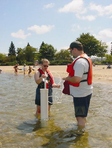
Figure 7. USGS scientists sample nearshore ground water for bacterial contamination. (33KB)
SEAMLESS BATHYMETRIC-TOPOGRAPHICAL MAPPING IN COASTAL AREAS
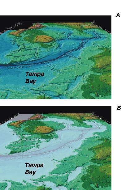
USGS scientists have begun to develop tools to evaluate how shoreline position and lake-level change affect extent of wetlands; navigation in shallow areas; available habitats for nearshore aquatic communities; and exposure of fish, birds, and other organisms to contaminated sediments. A digital elevation model (DEM) for coastal areas, for which the topographic and bathymetric maps are joined together to form a continuous topographic surface, has been identified as a critical element for many issues in coastal management. A successful demonstration project in the southeastern United States was recently completed by the USGS in cooperation with the National Ocean Service (NOS) of the National Oceanic and Atmospheric Administration (NOAA). In figure 8, illustration A depicts a seamless data set of the Tampa Bay estuary floor and surrounding land, created by integrating USGS digital elevation data with NOAA bathymetry data and reprojecting them to common datum. I llustration B depicts a sea-level rise of 10 feet. Seamless DEMs such as this can be applied in the Great Lakes coastal areas to define changing shorelines as in the case of water-level variation caused by lake-level management, coastal erosion, normal climatic variations, and climate change.
|
For further information, please contact:
Donna N. Myers, USGS Great Lakes Program |
REFERENCES CITED Conlon, T.D., 1998, Hydrogeology and simulation of ground-water flow in the sandstone aquifer, northeastern Wisconsin: U.S. Geological Survey Water-Resources Investigations Report 97-4096, p.30-31. Myers, D. N., and others, 2002, Strategic V ision for the U.S. Geological Survey in the Great Lakes-St. L awrence Region, 2001-2010: U.S. Geological Survey Open-File Report 02-193, p.16. |
|
For more information on programs described: USGS: http://water.usgs.gov |