Groundwater Levels in Huron County, 1996
In 1990, the U.S. Geological Survey (USGS) completed a study of the
hydrogeology of Huron County, Michigan (Sweat, 1991). In 1993, Huron County
and the USGS entered into an agreement to continue collecting water levels
at selected wells throughout Huron County. As part of the agreement, the
USGS has provided training and instrumentation for County personnel to
measure, on a quarterly basis, the depth to water below the land surface in
selected wells. The agreement includes the operation of continuous water-level
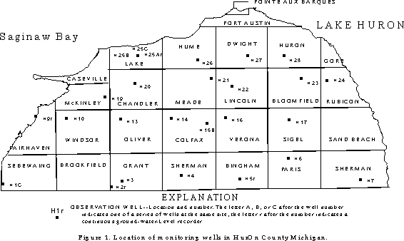
recorders installed on four wells in Bingham, Fairhaven, Grant and Lake
Townships (fig. 1). County personnel make quarterly water-level measurements
of 22 other wells. Once each year, County personnel are accompanied by USGS
personnel who provide a quality assurance/quality control check of all
measurements being made.
Precipitation and the altitude of Lake Huron are good indicators of
general climatic conditions and, therefore, provide an environmental context
for ground-water levels in Huron County. In general, Lake Huron water levels
in 1996 were about the same as they were from 1992-95 (NOAA, 1988-96),
although they were generally higher than the highest levels recorded in
1993, the highest year in the period of record. Precipitation was generally
within the normal range, but was higher, as a monthly average, than during
most preceding months. Precipitation was 11.25 inches more in 1996 than in
1995, and more than 6 inches greater than the long-term average for the
County.
Quarterly water-level measurements made during 1996 for the other
22 wells are shown in table 1. In general, water levels in the glaciofluvial
aquifer reflect seasonal variations, with maximum depths to water occurring in
late summer and early fall and minimum depths to water occurring in late
winter and early spring. In general, wells completed in the lower part of
the Marshall aquifer continue to show an increase in water-level altitude from
the original project period (1988-90) with many at new highs for the period of
record; wells completed in the upper part of the Marshall aquifer generally
had higher water-level altitudes compared to previous years, which is a change
from previous years. Wells completed in the Saginaw aquifer showed higher
water level altitudes in 1996 than in 1995, not only near the lake but also
farther inland, while water-level altitudes in wells completed in the
Coldwater confining unit continued to show small increases from both the
original project period and 1995. Water-level altitudes were higher throughout
the County during 1996 than in the previous year, with the exception of the
northwest corner of Colfax Township, where they were about 1 foot lower than
in 1995. All wells with recorders had higher water levels in September 1996
than in 1995. In well H5r, water levels had recovered to greater than the
long-term record from 1988-1995; in all other wells with recorders, levels
were still lower than the long-term average for September. Above average
precipitation for the year most likely accounts for most of the recovery
noted.
Publications:
Sweat, M.J., 1991, Hydrogeology of Huron County, Michigan: U.S. Geological Survey Water-Resources Investigations Report 91-4133, 68 p.
-----, 1995, Ground-Water Levels in Huron County, Michigan, March 1993 through December 1994: U.S. Geological Survey Open-File Report 95-430, 9 p.
-----, 1996, Ground-Water Levels in Huron County, Michigan, January 1995 through December 1995: U.S. Geological Survey Open-File Report 96-175, 8 p.
-----, 1997, Ground-Water Levels in Huron County, Michigan, January 1996 through December 1996: U.S. Geological Survey Open-File Report 97-___, 9 p.
Contacts:
Mike Sweat, U.S. Geological Survey, Water Resources Division, 6520
Mercantile Way, Suite 5, Lansing, MI 48911, (517) 887-8903,
mjsweat@usgs.gov
Table 1. Periodic depth to water for selected wells, Huron County, Michigan, 1996
[G, indicates well in glaciofluvial aquifer; S, indicates well in Saginaw aquifer;
M, indicates well in Marshall aquifer; C, indicates well in Coldwater confining unit]
-------------------------------------------------------------------------------

        Aqui-  Altitude of
Well     fer   measuring
Number  Code   point, in ft     3/96      6/96     9/96     12/96
-------------------------------------------------------------------------------

H1C       S       600.00        18.84    18.18    19.15    18.02

H2r       G       747.60        32.40    31.52    33.04    32.00

H3        M       731.70        30.14    29.00    29.43    28.88

H4        M       751.60        13.53    12.46    12.35    12.57

H5r       M       796.03        13.00    11.09    11.20    11.59

H6        M       781.50        14.37    13.63    13.15    13.10

H7        C       726.80        17.20    17.95    17.01    16.85

H9r       S       584.20        6.26      5.46     6.28     6.98

H10       S       617.07        24.71    24.20    24.84    24.26

H13       S       642.35        32.77    32.30    33.58    32.00

H14       M       681.30        5.69      4.49     5.02     4.13

H15B      M       751.20        16.88    16.40    16.59    15.78

H16       M       771.50        29.82    28.45    28.61    28.85

H17       M       751.00         6.43     5.81     5.46     5.50

H19       M       611.90         4.55     5.30     4.70     3.29

H20       S       631.00        14.97    13.77    13.99    13.58

H21       M       702.90         9.60     9.93     9.34     9.56

H22       M       695.50        14.24    13.52    13.21    13.35

H23       C       721.80         9.62     9.51     9.52     9.45

H24       C       691.50        25.70    25.52    25.55    25.25

H25Ar     M       600.80         6.55     5.94     6.58     5.52

H25B      M       601.00         2.84     2.17     2.64     1.92

H25C      M       602.20         3.68     3.38     3.74     3.38

H26       M       662.70         5.00     4.20     3.68     4.14

H27       M       716.50        33.10     32.80    32.90    32.12

H28       M       691.70        19.44     19.18    17.94    18.60

------------------------------------------------------------------------------
More Information:
Huron County Information
More Huron County Information