

|

|

|

|

|

|
|---|---|---|---|---|---|
| ° Surface Water ° Ground Water ° Water Quality ° Water Use ° Bioremediation ° Urban Hydrology ° Great Lakes Program ° Program Listing | |||||
Ground-Water StationsTable 1 lists the ground-water stations established as part of the statewide observation network. In addition to ground-water information collected at sites listed in table 1, chemical analyses of ground water have been collected at other locations in the state. Further information is available upon request. The well-numbering system for Michigan indicates the location of wells within the rectangular subdivision of the land with reference to the Michigan meridian and base line. The first two segments of the well number designate township and range, the third segment of the number designates the section, and the letters A through D designate successively smaller subdivisions of the section as shown below. Thus, a well designated as 32N 6E 16CCCB would be located to the nearest 2. 5 acres (1 hectare) and would be within the shaded area in section 16. 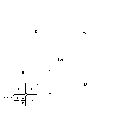
For many wells in this report, locations are only given to the nearest 40-acre (16 hectares) tract, for example, 16CC. In the event that two or more wells are located in the same tract, a sequential number designation is added--for example, 16CC1, 16CC2, 16CC3, etc. |
|
|---|---|
Ground Water Stations by County |
|
|
Branch County Calhoun County Chippewa County Clare County Clinton County Eaton County Huron County Ingham County Kalamazoo County Livingston County Marquette County Oakland County Roscommon County Washtenaw County |
Click on the blue counties to retrieve data stations in that county.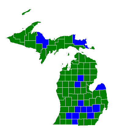
|
|
Table 1. Ground-water hydrologic data stations, by county. [Letters after well name designate type of levels made: (A) annual measurement, (D) daily measurement, (M) monthly measurement, (Q) quarterly measurement, (R) continuous record. (QC) after well name designates that a quality analyses of chemical, organic, and pesticide were made..]
                                                                                                        Depth in
                                        Station number                  Local well number                  feet
					--------------			-----------------		---------
BRANCH COUNTY
Coldwater Test 4 (R)                    415602084593701 		   6S 6W 22CABA			   113


CALHOUN COUNTY
Penfield Township (R, QC) 		422032085091801 		   1S 7W 32BDCC1 		    95


CHIPPEWA COUNTY
Raco (R) 				462159084442201 		   46N 4W 24DADA 		    54

Back to top of listing.
CLARE COUNTY
Clare (R) 				434900084462501 		   17N 4W 34DCAD 		    91


CLINTON COUNTY
Quarantine Farm (M) 			424618084340401 		   5N 2W 32DCDA 		   135
MDOT, U.S. 27 				425410084323501 		   6N 2W 16DDAD 		    26


EATON COUNTY
Lansing, Stiefel (R) 			424058084380301 		   3N 2W 2BA 			    66
Robins Road (R) 			424435084365001 		   4N 3W 12CDAD 		   381

Back to top of listing.
HURON COUNTY
Grant Township (R) 			434103083130301 		   15N 11E 32BBCB 		    91
Fairhaven Township (R) 			434947083233301 		   16N 09E 02CDCA 		   180


INGHAM COUNTY
Lansing, Cedar (R) 			423127084321901 		   4N 2W 16DAAA 		   417
Holt (R) 				423805084311801 		   3N 2W 23BCBD 		   188
Lansing, Davis (R) 			424040084351401 		   3N 2W 6ACAD1 		    --
					424111084360701 		   4N 2 W 32CC 		           204
Fenner Aboretum (R) 			424235084311201 		   4N 2W 27BB 			   215
Lansing, P-5 (M) 			424312084321801 		   4N 2W 22BC 			   338
Lansing, Logan (R) 			424424084340301 		   4N 2W 17ABAA 		   424
Lansing, Seymour (R) 			424502084331301 		   4N 2W 9BDAD 			   401
Lansing, Muskegon (R) 			424521084342101 		   4N 2W 5CDD1 			   418

Back to top of listing.
KALAMAZOO COUNTY
Portage (R) 				421151085351601 		   3S 11W 22BBCD 		   102
Upjohn 28 (R) 				421249085330901 		   3S 11 W 14AA 		   233
Kalamazoo, Atwater (R) 			421325085404801 		   3S 12W 11BDAD 		   248
Kalamazoo, Sabo, D (R) 			421332085401901 		   3S 12W 11AD1 		   300
Kalamazoo, Sabo, S (R) 			421332085401901 		   3S 12 W 22AD2		    38
Kalamazoo, K325 (R) 			421435085353701 		   3S 11 W 4ABAD1 		    36
Kalamazoo, K32D (R) 			421435085353702 		   3S 11W 4ABAD2 		   144
Kalamazoo, Colony (R) 			421448085383601 		   2S 11W 31CD 			   226
Kalamazoo, Emerald (R) 			421457085325801 		   2S 11W 36CB 			   226
Kalamazoo, Morrow (R) 			421614085270801 		   2S 10W 26BBCC 		    27
Kalamazoo, Maple (R) 			421614085354001 		   2S 11W 28AA 			   245
					421641085350601 		   2S 11W 22CD 			   137
Kalamazoo, Kendall (R) 			421716085373702 		   2S 11W 20BB2 		   106
Kalamazoo, Campbell (R) 		421918085283801 		   2S 10W 4D 		            13

Back to top of listing.
LIVINGSTON COUNTY
American Aggregate (R, QC) 		422853083402801 		   1N 6E 13DBAB 		    29


MARQUETTE COUNTY
Ely Township (R, QC) 			462938087475901 		   47N 28W 3CCDC 		    72


OAKLAND COUNTY
Honeywell Lake Road (R) 		423622083390701 		   2N 7E 5AAD 			    44
Fish Lake Road (R) 			424109083384301 		   3N 7E 5BA 			    49
Holly Recreation Area (M) 		425116083321501 		   5N 8E 8ACAC 			    42

Back to top of listing.
ROSCOMMON COUNTY
Exp. Station (R, QC) 			442722084350701 		   24N 2W 20BABA 		    14

Back to top of listing.
WASHTENAW COUNTY
Ypsilanti Township 117 (R) 		421220083332501 		   3S 7E 24CDBC 		    75
Ann Arbor (R, QC) 			421322083441301 		   3S 6E 16BCCD 		    55
Ypsilanti, Gilbert (R) 			421427083362301 		   3S 7E 9ADBC1 		    94
Ypsilanti, Superior 			421532083382001 		   3S 7E 5BBAC 			    70
|
|
Last Modified: Tuesday, 03-Jan-2017 11:07:34 EST
For technical questions or concerns about this page contact:
Webmaster <gs-w-milns_webmaster@usgs.gov>