A Preliminary Investigation of Contaminant Distribution and Movement at
Grassy Island, Wyandotte Unit of Shiawassee National Wildlife Refuge, Michigan
The US Fish and Wildlife Service (USFWS), in collaboration with USGS Water
Resources Division and Biological Resources Division, is funding an
investigation of the distribution and composition of contaminated sediments on
Grassy Island. From 1961 through 1983, Grassy Island, in the Detroit River
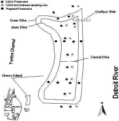
(figure 1), was operated as a confined disposal facility (CDF) for the Detroit
District of the Army Corps of Engineers (Corps). Dikes composed of river
sediments and rubble were initially constructed and later augmented to increase
the capacity of Grassy Island for dredged sediments. The disposal site was
limited to 72 acres. Grassy Island was the first CDF on the Detroit River and
did not incorporate later design features which reduce movement of contaminants
from CDFs. Dredged river sediments, principally from the River Rouge, were
deposited on the island. River Rouge sediments typically contain high
concentrations of metals, organic compounds, and other contaminants. In 1961,
Grassy Island and surrounding shallow waters became part of Wyandotte National
Wildlife Refuge, principally because of the concentrations of migratory
waterfowl which feed on the wild celery in the shallows on the west side of the
island.

Figure 1. Map showing location of Grassy Island and proposed sample sites.
Previous investigations by the Corps, Michigan Department of Environmental
Quality (MDEQ), US Environmental Protection Agency (EPA), and the Detroit River
Remedial Action Plan (RAP) indicate that the River Rouge sediments and Detroit
River sediments adjacent to Grassy island are contaminated by metals and organic
compounds. Previous investigations by the USFWS indicate that Grassy Island
sediments are contaminated and that migratory waterfowl show exposure to these
same contaminants.
The goal of this interdisciplinary, multiagency investigation is to
characterize the distribution and composition of contaminated sediments over
Grassy Island. This will involve soil borings, monitoring wells, soil and water
samples, and laboratory tests. A marine-geophysical study of the shoal grounds
surrounding the Island was completed in October, 1996. These data are currently
being analyzed and a report prepared. Water, soil, and sediment quality work is
scheduled to begin by June, 1997, and will include the installation of
piezometers using USGS standard methods as documented in OFR 89-396 and OFR
95-398.
Publications:
Sweat, M.J., 1997, Marine-Seismic Survey of Grassy island, Wyandotte Unit of
Shiawassee National Wildlife Refuge: U.S. Geological Survey Administrative
Report, in press.
Contacts:
Mike Sweat, U.S. Geological Survey, Water Resources Division, 6520 Mercantile
Way, Suite 5, Lansing, MI 48911, (517) 887-8903, mjsweat@usgs.gov
Doug Spencer, U.S. Fish and Widlife Service, Shiawassee National Wildlife
Refuge, 6975 Mower Road, Saginaw, MI, 48601, (517)777-5930, Doug_Spencer@mail.fws.gov
More Information:
- U.S. Fish and Wildlife Service
- Shiawassee National Wildlife
Refuge
- U.S. Geological Survey, Biological Resources
Division
- Great Lakes Science Center
- U.S. Army Corps of Engineers,
Detroit District
