 |
|
|
||||
| Michigan Water Science Center |
Graph of Transect 8 at Big Rapids
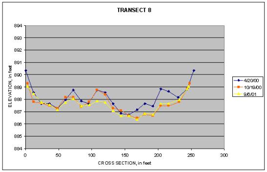 |
Bed profiles measured at transect 8 show some erosion occurring between the prior(4/20/2000) and short-term(10/19/2000) profiles. Because of the location of this profile, this was probably an annual event with sediment deposited during low water then remobilized with the spring high flows. The one-year(9/6/2001) profile when compared to the short-term(10/19/2000) profile shows some additional erosion in the channel. |
||||||||||||||||||||||||||||||||||||||||||||||||||||||||||||||||||||||||||||||||||||||||||||||||||||||||||||||||||||||||||||||||||||||||||||||||
|
|||||||||||||||||||||||||||||||||||||||||||||||||||||||||||||||||||||||||||||||||||||||||||||||||||||||||||||||||||||||||||||||||||||||||||||||||

![]() U.S. Department of the Interior |
U.S. Geological Survey
U.S. Department of the Interior |
U.S. Geological Survey
URL:
Page Contact Information: Webmaster(gs-w-milns_webmaster@usgs.gov)
Page Last Modified: Last modified: August 10 2005 11:20:57.