 |
|
|
||||
| Michigan Water Science Center |
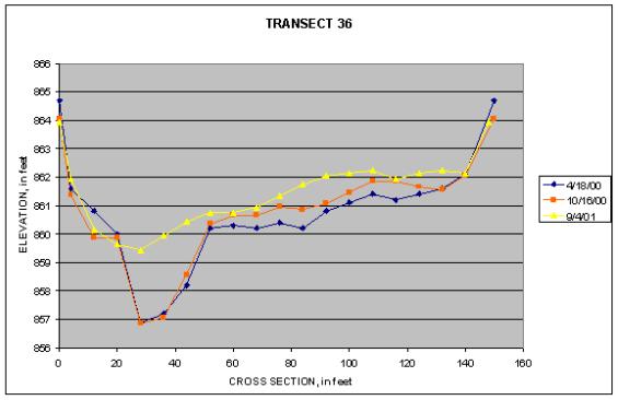
Graph of Transect 36 at Big Rapids
|
Bed profiles measured at transect 36 show that there was some change in bed elevation between the pre-dam remnant removal(4/18/2000) profile and the profile made about two months after the removal(10/16/2000). This section of the river is still impacted by the 1966 removal. The profile made a year after the dam-remnant removal(9/4/2001) shows that the deeper channel has been filled in and a layer of sediment has been deposited over most of the riverbed. These are, in part, finer sediments that were mobilized by the dam remnant removal. |
|||||||||||||||||||||||||||||||||||||||||||||||||||||||||||||||||||||||||||||||||||||||||||||||||||||||||||||||||||||||||||||||||||
|
||||||||||||||||||||||||||||||||||||||||||||||||||||||||||||||||||||||||||||||||||||||||||||||||||||||||||||||||||||||||||||||||||||

![]() U.S. Department of the Interior |
U.S. Geological Survey
U.S. Department of the Interior |
U.S. Geological Survey
URL:
Page Contact Information: Webmaster(gs-w-milns_webmaster@usgs.gov)
Page Last Modified: Last modified: August 10 2005 11:20:57.