 |
|
|
||||
| Michigan Water Science Center |
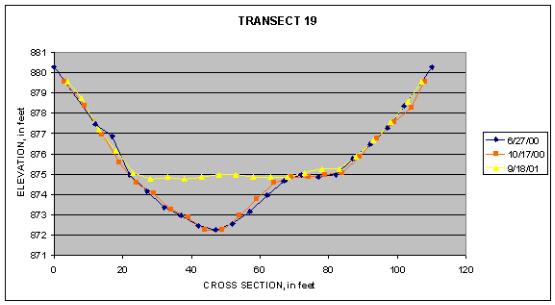
Graph of Transect 19 at Big Rapids
|
Bed profiles show no change to the channel in the first few months after the dam remnant removal(10/17/2000). The profile taken a year later(9/18/2001), however, shows substantial aggradation of the deeper section of the channel. |
||||||||||||||||||||||||||||||||||||||||||||||||||||||||||||||||||||||||||||||||||||||||||||||||||||||||||||||||||||||||||||||||||||||||||||||||
|
|||||||||||||||||||||||||||||||||||||||||||||||||||||||||||||||||||||||||||||||||||||||||||||||||||||||||||||||||||||||||||||||||||||||||||||||||

![]() U.S. Department of the Interior |
U.S. Geological Survey
U.S. Department of the Interior |
U.S. Geological Survey
URL:
Page Contact Information: Webmaster(gs-w-milns_webmaster@usgs.gov)
Page Last Modified: Last modified: August 10 2005 11:20:57.