 |
|
|
||||
| Michigan Water Science Center |
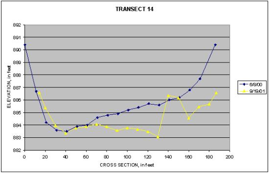
Graph of Transect 14 at Big Rapids
|
Bed profiles measured at transect 14 show that a substantial amount of sediment was removed from this cross section during the first year after the dam removal(9/19/2001). The sudden increase in bed elevation near 130 feet is a rock crib that was almost completely buried at the time of the first profile(6/8/2000). |
||||||||||||||||||||||||||||||||||||||||||||||||||||||||||||||||||||||||||||||||||||
|
|||||||||||||||||||||||||||||||||||||||||||||||||||||||||||||||||||||||||||||||||||||

![]() U.S. Department of the Interior |
U.S. Geological Survey
U.S. Department of the Interior |
U.S. Geological Survey
URL:
Page Contact Information: Webmaster(gs-w-milns_webmaster@usgs.gov)
Page Last Modified: Last modified: August 10 2005 11:20:57.