 |
|
|
||||
| Michigan Water Science Center |
|
Project Chief Russ Minnerick Predicting Water Clarity Statewide Water Resources Monitoring Protection of Drinking Water Sources Effects of Land Use on Water Quality
Restoring Natural Flow Regimes Research and Technical Assistance at Contaminated Sites Table of Contents |
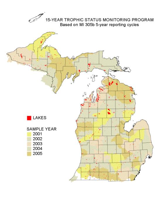
15-Year Trophic Status Monitoring Program, Based on MI 305b 5-year reporting cycles (45 KB)
Michigan has nearly 3,500 lakes over 25 acres in size. Of these lakes approximately 730 are accessible to the general public. The USGS, in cooperation with MDEQ, has designed and is implementing a statewide network to assess the current trophic status and water quality conditions of these public waters. Each lake will be evaluated once in a fifteen-year period starting in 2001. During its specified year each lake will be sampled once in early spring and once in late summer to determine water-quality characteristics. The year that the lake will be sampled is determined by the watershed unit in which the lake is located. Each year, 7 to 10 of the 45 major watersheds in Michigan will be monitored and assessed. These basins are monitored on a five-year cycle in order to assist in (1) statewide water quality assessments, (2) the National Pollutant Discharge Elimination System (NPDES) permitting process, and (3) resource management decisions. Remote-sensing satellite data which correlates closely with water clarity measurements will be used to extend trophic-status assessments to other lakes and to monitor changes during this fifteen year period. Links to Other Resources: Regional Earth Science Applications Center (RESAC) - Upper Midwest - @Michigan State University NASA - Testing the Waters: Using Satellites to Monitor Lake Water Quality
|

![]() U.S. Department of the Interior |
U.S. Geological Survey
U.S. Department of the Interior |
U.S. Geological Survey
URL:
Page Contact Information: Webmaster(gs-w-milns_webmaster@usgs.gov)
Page Last Modified: Last modified: April 15 2008 15:34:40.