Glacial Aquifer System Groundwater Availability Study
ContactHoward W. Reeves
USGS IN YOUR STATEUSGS Water Science Centers are located in each state. 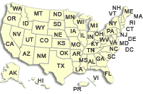
|
Supplementary Material for SIR2015-5105As part of the National Water Availability and Use Program established by the U.S. Geological Survey (USGS) in 2005, this study took advantage of about 14 million records from State-managed collections of water-well drillers’ records and created a database of hydrogeologic properties for the glaciated United States. The water-well drillers’ records were standardized to be relatively complete and error-free and to provide consistent variables and naming conventions that span all State boundaries. Maps and geospatial grids were developed for (1) total thickness of glacial deposits, (2) total thickness of coarse-grained deposits, (3) specific-capacity based transmissivity and hydraulic conductivity, and (4) texture-based estimated equivalent horizontal and vertical hydraulic conductivity and transmissivity. The information included in these maps and grids is required for most assessments of groundwater availability, in addition to having applications to studies of groundwater flow and transport. The texture-based estimated equivalent horizontal and vertical hydraulic conductivity and transmissivity were based on an assumed range of hydraulic conductivity values for coarse and fine-grained deposits and should only be used with complete awareness of the methods used to create them. However, the maps and grids of texture-based estimated equivalent hydraulic conductivity and transmissivity may be useful for application to areas where a range of measured values is available for re-scaling. Please click on a state to view available PDF files and links to data sets for each state. Note, not all states have all figures available and some states have none (AK, CT, ME, MO, and NJ). ![[Map: States overlain by Glacial deposits.]](SuppWebMap.jpg)
PDF files for the entire study area
|
![]() U.S. Department of the Interior |
U.S. Geological Survey
U.S. Department of the Interior |
U.S. Geological Survey
URL: http://mi.water.usgs.gov/projects/WaterSmart/Map.html
Page Contact Information: gs-w-milns_webmaster@usgs.gov
Page Last Modified: Friday, 7-April-2016 13:24:46 EST
