USGS - science for a changing world

Michigan Water Science Center


Scientific Investigations Report 2006-5071


Scientific Investigations Report 2006-5071

USGS Michigan

Water Science Center Home

USGS in Your State

USGS Water Science Centers are located in each state.

 [Map: There is a USGS Water Science Center office in each State.] Washington Oregon California Idaho Nevada Montana Wyoming Utah Colorado Arizona New Mexico North Dakota South Dakota Nebraska Kansas Oklahoma Texas Minnesota Iowa Missouri Arkansas Louisiana Wisconsin Illinois Mississippi Michigan Indiana Ohio Kentucky Tennessee Alabama Pennsylvania West Virginia Georgia Florida Caribbean Alaska Hawaii New York Vermont New Hampshire Maine Massachusettes South Carolina North Carolina Rhode Island Virginia Connecticut New Jersey Maryland-Delaware-D.C.

Water Resources of Lake St. Clair and its U.S. Tributaries

Water Resources of Lake St. Clair and its U.S. Tributaries

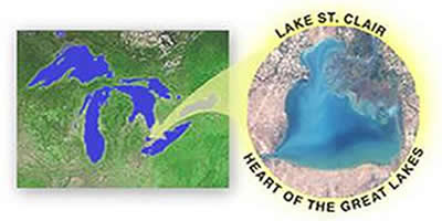
In 2003, the Lake St. Clair Regional Monitoring Project (LSCRMP) partners, consisting of the Macomb County Health Department, Environmental Consulting & Technology, Inc., Oakland County Drain Commission, St. Clair County Health Department, Wayne County Department of the Environment, Michigan Department of Environmental Quality, and the U.S. Geological Survey, developed plans for a 3-year comprehensive assessment of the hydrological, chemical, and physical state of the surface water of Lake St. Clair and its tributaries. The program was in response to citizens concerns about public health issues such as beach closings, drinking water threats, and fish consumption advisories.

The study included continuous water-quality monitoring at 13 fixed stations; automatic and discrete (grab) sampling during 10 wet weather events; continuous and miscellaneous streamflow measurements at 23 locations; rainfall monitoring at 5 locations, sampling of 4 lakes, and analyses of historical water-and bed-sediment-quality data. Descriptions of the LSCRMP and data collected during the project are available at http://www.lakestclairdata.net.

The USGS, working as cooperative project partner, documented their findings in the following reports:

  • Results of an assessment of nonpoint-source loads of nutrients and total-suspended solids in the Black, Belle, and Pine River basins utilizing the U.S. EPA’s PLOAD model are shown in Scientific Investigations Report 2006-5071.
  • The spatial distribution and concentrations of contaminants of concern in streambed and lakebed sediments in the U.S. part of the Lake St. Clair basin is described in Scientific Investigations Report 2006-5189.
  • A summary of bacteria and emerging-chemical-contaminant monitoring in the St. Clair River/Lake St. Clair basin is available in Open File Report 2007-1083.
  • Numerous cooperative water-resources monitoring efforts conducted in the St. Clair/Lake St. Clair basin over the last 100 years are described in Open File Report 2007-1148.
  • Stream-water quality during storm-runoff events and low-flow periods in the St. Clair River/lake St. Clair basin from the early 1970’s through 2005 is described in Open File Report 2007-1201.
  • A comprehensive assessment of the hydrological, chemical, and physical state of the surface water of Lake St. Clair and its tributaries is documented in Scientific Investigations Report 2007-5172.


USGS Home Water Climate Change Core Science Ecosystems Energy and Minerals Env. Health Hazards

Accessibility FOIA Privacy Policies and Notices

USA.gov logo U.S. Department of the Interior | U.S. Geological Survey
URL: http://mi.water.usgs.gov/projects/WRofLakeStClairIntro/index.html
Page Contact Information: gs-w-milns_webmaster@usgs.gov
Page Last Modified: Tuesday, 03-Jan-2017 11:07:36 EST

Location of the Great Lakes Basin in the United States and Canada.  Click on the image to view a larger version.