Michigan Water Science Center
Project ChiefLori Fuller
CURRENT CONDITIONS
DATA CENTERReal-time data Historical data
|
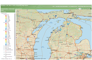
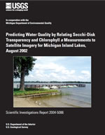
Estimating Lake Water Clarity OverviewA technique was developed by USGS, modeled after Olmanson and others (2001), to estimate Secchi-disk transparency (eSDT) and corresponding estimated trophic state index (eTSI) values based on the Carlson's Trophic State Index (TSI) in inland lakes greater than 20 acres using Landsat satellite imagery.
Remote Sensing - Reports/Fact Sheets
Downloadable Data/MetaDataWe are interested to learn how the data is being used. Please contact Lori Fuller with your information and project. Estimated Secchi-disk transparency (eSDT) and corresponding estimated trophic state index (eTSI) values. Data is available for download in shapefile format with metadata: 1999-2000 eSDT — shapefile metadata
2002 eSDT — shapefile metadata 2013 eSDT — shapefile metadata Shapefiles of the distributions are contained in a ZIP file (.ZIP). Microsoft® Windows® 7 and up have a built-in programs that allows a file or folder to be compressed or uncompressed. You can also use WinZip®, PKZip®, or similar program to extract in Microsoft® Windows®; use Stuffit Expander™ or similar to unzip on Macintosh; Use UnZip or similar program to extract on UNIX® computers. NOTICE: Any use of trade, firm, or product names is for descriptive purposes only and does not imply endorsement by the U.S. Federal Government. "Microsoft and Windows are either registered trademarks or trademarks of Microsoft Corporation in the United States and/or other countries." All other trademarks and trade names are the property of their respective owners. Remote Sensing - LinksRemote Sensing of Water Resources — University of Minnesotahttp://water.umn.edu/index.htmlLakeSat.org — Mapping Lake Clarity: About the Maphttp://www.lakesat.org/maptext1.phpLakeSat.org — Lake Water Clarity Monitoring and Analysis With Satellite Remote Sensing at the University of Wisconsin-Madisonhttp://www.lakesat.org/Wisconsin Department of Natural Resources — Self-Help Citizen Lake Monitoring Networkhttp://dnr.wi.gov/lakes/CLMN/Michigan Surface Water Information Management System (MiSWIMS)
|
![]() U.S. Department of the Interior |
U.S. Geological Survey
U.S. Department of the Interior |
U.S. Geological Survey
URL: http://mi.water.usgs.gov/projects/WaterSmart/index.html
Page Contact Information: gs-w-milns_webmaster@usgs.gov
Page Last Modified: Wednesday, 26-Dec-2012 17:58:46 EST