Great Lakes Basin Pilot
Description of Study
At the request of Congress, the U.S. Geological Survey (USGS) is assessing the availability and use of the Nation’s water resources to gain a clearer understanding of the status of our water resources and the land-use, water-use, and natural climatic trends that affect them. The goal of the National Assessment of Water Availability and Use Program is to improve our ability to forecast water availability for future economic and environmental uses. Simply put, the assessment will help characterize how much water we have now, how water availability is changing, and how much water we can expect to have in the future.
Water availability is a function of many factors, including the quantity and quality of water and the laws, regulations, economics, and environmental factors that control its use. The focus of the Great Lakes Basin study is on improving fundamental knowledge of the water balance of the basin, including the flows, storage, and water use by humans. An improved quantitative understanding of the basin’s water balance not only provides key information about water quantity but also is a fundamental basis for many analyses of water quality and ecosystem health. |
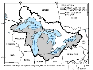 |
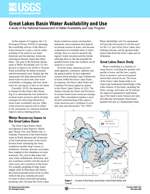
| Location of the Great Lakes Basin in the United States and Canada. Click on the image to view a larger version. |
Products to Date
Approach
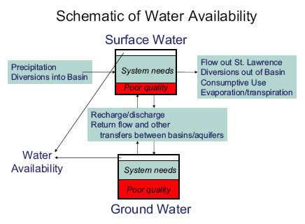
An understanding of water availability in an area requires more than information regarding the amount of water in a system. Water managers need to understand how the system changes in time and how it reacts to changes in environmental conditions and use. Constraints on use including current off-stream use, in-stream requirements, and water quality limitations also must be recognized. The Great Lakes Basin Pilot focuses on developing the understanding of the dynamics of the water resources in the basin in terms of the flows and storage of water in both ground and surface water. The Pilot also seeks to illustrate the importance of water-use data to quantifying water availability. Other constraints including water quality and in-stream flow requirements are subjects of other USGS programs.
The major tasks include:
The major tasks include:
The major tasks include:
-
Compile consumptive-use coefficients by water-use categories for the Great Lakes Basin and climatically similar areas. This compilation is in a report that includes:
- consumptive-use coefficients by water-use categories;
- a selected statistical analysis;
- summary tables by geographical area and water-use category;
- an annotated bibliography of references with consumptive-use coefficients; and
- an appendix with detailed consumptive-use coefficient tables from selected references
for the Great Lakes Basin and areas climatically similar to the Great Lakes Basin, and selected references for elsewhere in the world.
- Analysis of return flow and water use data in Ohio and water-use data in Indiana, and Wisconsin for consumptive-use coefficients and monthly variability of water use and consumptive use. This analysis will be compared to consumptive-use coefficient statistics found by Shaffer and Runkle (2007) for water-use categories.
- Compilation and publication of water-use data and estimates for the U.S. side of the Great Lake Basin water use by Hydrologic Unit Code for 2005.
For additional information, please contact:
Howard W. Reeves, Project Chief
U.S. Geological Survey
Michigan Water Science Center
6520 Mercantile Way, Suite 5
Lansing, Michigan 48911
Telephone: (517) 887-8914
Fax: (517) 887-8937
Email: hwreeves@usgs.gov
Related Information on Water Availability:
|